Landkarten
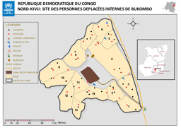
Provinz Nordkivu: Lagekarte: Landkarte zu Binnenvertriebenen in Bukombo
Republique Democratique du Congo; Nord-Kivu: Site des Personnes Deplacées Internes de Bukombo (Landkarte oder Infografik, Französisch)
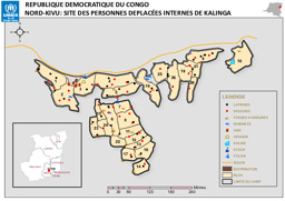
Provinz Nordkivu: Lagekarte: Landkarte zu Binnenvertriebenen in Kalinga
Republique Democratique du Congo; Nord-Kivu: Site des Personnes Deplacées Internes de Kalinga (Landkarte oder Infografik, Französisch)
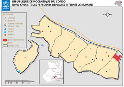
Provinz Nordkivu: Lagekarte: Landkarte zu Binnenvertriebenen in Kilimani
Republique Democratique du Congo; Nord-Kivu: Site des Personnes Deplacées Internes de Kilimani (Landkarte oder Infografik, Französisch)
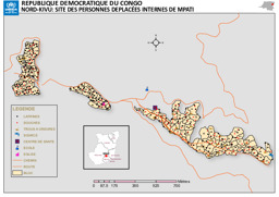
Provinz Nordkivu: Lagekarte: Landkarte zu Binnenvertriebenen in Mpati
Republique Democratique du Congo; Nord-Kivu: Site des Personnes Deplacées Internes de Mpati (Landkarte oder Infografik, Französisch)
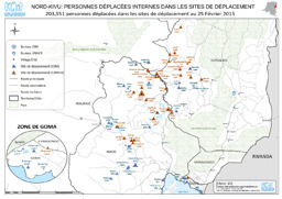
Provinz Nordkivu: Lagekarte: Landkarte zu Aufenthaltsorten von Binnenvertriebenen (mit Stand von 25. Februar 2015)
Nord-Kivu; Personnes déplacées internes dans les sites de déplacement; 203,551 personnes déplacées dans les sites de déplacement au 25 Février 2015 (Landkarte oder Infografik, Französisch)
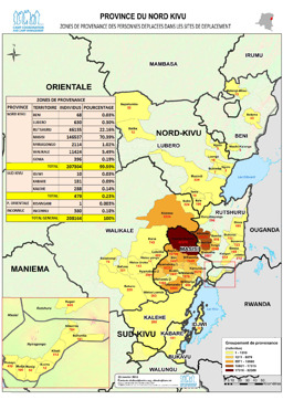
Provinz Nordkivu: Lagekarte: Landkarte zur Verteilung von Binnenvertriebenen (mit Stand von 25. Jänner 2015)
Province du Nord Kivu; Zonas de Provenance des Personnes Deplacees dans les Sites de Deplacement (Landkarte oder Infografik, Französisch)
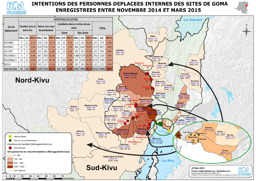
Region Goma: Lagekarte: Landkarte zu den Bestimmungsorten von Binnenvertriebenen, die sich zwischen November 2014 und März 2015 registriert haben
Intentions des personnes deplacees internes des sites de Goma enregisterees entre novembre 2014 et mars 2015; 25 March 2015 (Landkarte oder Infografik, Französisch)
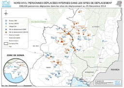
Provinz Nordkivu: Lagekarte: Landkarte zu Aufenthaltsorten von Binnenvertriebenen (mit Stand von 25. Dezember 2014)
Nord-Kivu; Personnes déplacées internes dans les sites de déplacement; 208,636 personnen déplacées dans les sites de déplacement au 25 Décembre 2014 (Landkarte oder Infografik, Französisch)
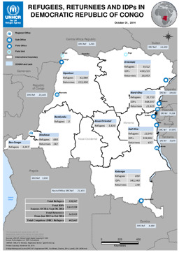
Lagekarte: Landkarte zu Vertreibung (Verteilung von Flüchtlingen; Verteilung von Rückkehrer·innen; Verteilung von Binnenvertriebenen) (mit Stand von 31. Oktober 2014)
Refugees, Returnees and IDPs in Democratic Republic of Congo; October 31, 2014 (Landkarte oder Infografik, Englisch)
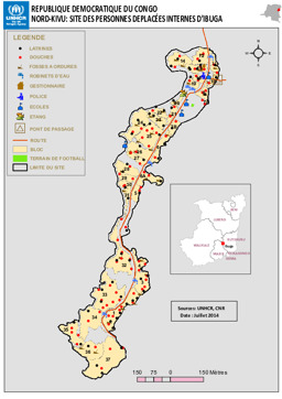
Provinz Nordkivu: Lagekarte: Landkarte zu Binnenvertriebenen in Ibuga
Republique Democratique du Congo; Nord-Kivu: Site des Personnes Deplacées Internes D'Ibuga (Landkarte oder Infografik, Französisch)
Gefundene Dokumente: 552
