Landkarten
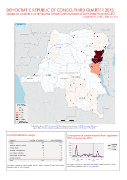
Kurzübersicht über Konfliktvorfälle aus dem Armed Conflict Location & Event Data Project (Berichtszeitraum 3. Quartal 2015)
DR Kongo, 3. Quartal 2015: Kurzübersicht über Vorfälle aus dem Armed Conflict Location & Event Data Project (ACLED) (Landkarte oder Infografik, Englisch)
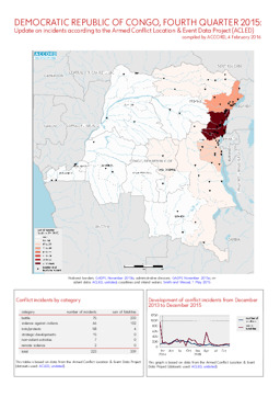
Kurzübersicht über Konfliktvorfälle aus dem Armed Conflict Location & Event Data Project (Berichtszeitraum 4. Quartal 2015)
DR Kongo, 4. Quartal 2015: Kurzübersicht über Vorfälle aus dem Armed Conflict Location & Event Data Project (ACLED) (Landkarte oder Infografik, Englisch)
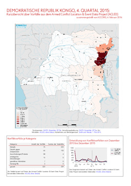
Kurzübersicht über Konfliktvorfälle aus dem Armed Conflict Location & Event Data Project (Berichtszeitraum 4. Quartal 2015)
DR Kongo, 4. Quartal 2015: Kurzübersicht über Vorfälle aus dem Armed Conflict Location & Event Data Project (ACLED) (Landkarte oder Infografik, Deutsch)
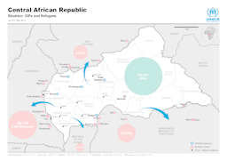
Lagekarte: Landkarte zu Flüchtlingen sowie Binnenvertriebenen und UNHCR-Stützpunkten in und um die Zentralafrikanische Republik (mit Stand von 31. Dezember 2015)
Central African Republic - Situation: IDPs and Refugees; as of 31 Dec 2015 (Landkarte oder Infografik, Englisch)
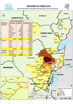
Provinz Nordkivu: Lagekarte: Landkarte zur Herkunft von Vertriebenen (mit Stand von 15. Jänner 2016)
Province du Nord Kivu - Zones de provenance des personnes déplacées dans les sites de déplacement (Landkarte oder Infografik, Französisch)
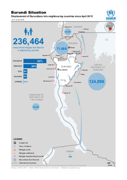
Lagekarte: Landkarte zur Verteilung von burundischen Flüchtlingen in benachbarten Ländern (mit Stand von April 2015)
Burundi Situation; Displacement of Burundians into neighbouring countries since April 2015 (Landkarte oder Infografik, Englisch)
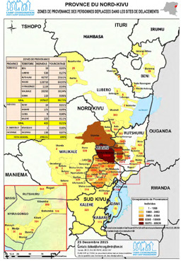
Provinz Nordkivu: Lagekarte: Landkarte zur Herkunft von Vertriebenen (mit Stand von 25. Dezember 2015)
Province du Nord-Kivu; Zones de provenance des personnes deplacées dans les sites de déplacements (Landkarte oder Infografik, Französisch)
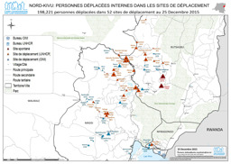
Provinz Nordkivu: Lagekarte: Landkarte zu Aufenthaltsorten von Binnenvertriebenen (mit Stand von 25. Dezember 2015)
Nord-Kivu: Personnes déplacées internes dans les sites de déplacement; 198,221 personnes déplacées dans 52 sites de déplacement au 25 Decembre 2015 (Landkarte oder Infografik, Französisch)

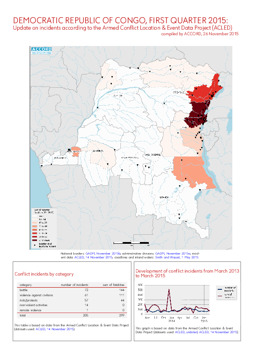
Kurzübersicht über Konfliktvorfälle aus dem Armed Conflict Location & Event Data Project (Berichtszeitraum 1. Quartal 2015)
Demokratische Republik Kongo, 1. Quartal 2015: Kurzübersicht über Vorfälle aus dem Armed Conflict Location & Event Data Project (ACLED) (Landkarte oder Infografik, Deutsch)
Kurzübersicht über Konfliktvorfälle aus dem Armed Conflict Location & Event Data Project (Berichtszeitraum 1. Quartal 2015)
Demokratische Republik Kongo, 1. Quartal 2015: Kurzübersicht über Vorfälle aus dem Armed Conflict Location & Event Data Project (ACLED) (Landkarte oder Infografik, Englisch)
Gefundene Dokumente: 552
