Landkarten

Kurzübersicht über Konfliktvorfälle aus dem Armed Conflict Location & Event Data Project (Berichtszeitraum 2. Quartal 2014)
Demokratische Republik Kongo, 2. Quartal 2014: Kurzübersicht über Vorfälle aus dem Armed Conflict Location & Event Data Project (ACLED) (Landkarte oder Infografik, Deutsch)
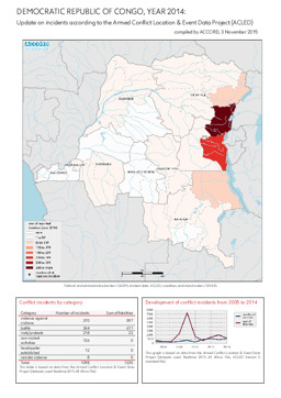
Kurzübersicht über Konfliktvorfälle aus dem Armed Conflict Location & Event Data Project (Berichtszeitraum Jahr 2014)
Demokratische Republik Kongo, Jahr 2014: Kurzübersicht über Vorfälle aus dem Armed Conflict Location & Event Data Project (ACLED) (Landkarte oder Infografik, Englisch)
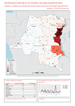
Kurzübersicht über Konfliktvorfälle aus dem Armed Conflict Location & Event Data Project (Berichtszeitraum 2. Quartal 2014)
Demokratische Republik Kongo, 2. Quartal 2014: Kurzübersicht über Vorfälle aus dem Armed Conflict Location & Event Data Project (ACLED) (Landkarte oder Infografik, Englisch)
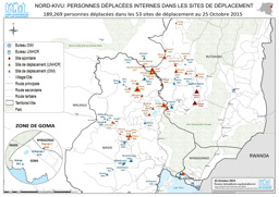
Provinz Nordkivu: Lagekarte: Landkarte zu Aufenthaltsorten von Binnenvertriebenen (mit Stand von 25. Oktober 2015)
Nord-Kivu; Personnes déplacées internes dans les sites de déplacement (Landkarte oder Infografik, Französisch)
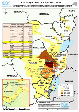
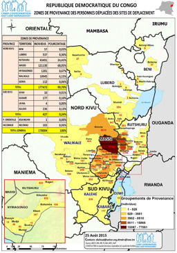
Lagekarte: Landkarte zu Herkunftsorten von Vertriebenen (mit Stand von 25. Oktober 2015)
Republique Democratique du Congo, Zones de provenance des personnes éplacées dans les 53 sites de deplacement (Landkarte oder Infografik, Französisch)
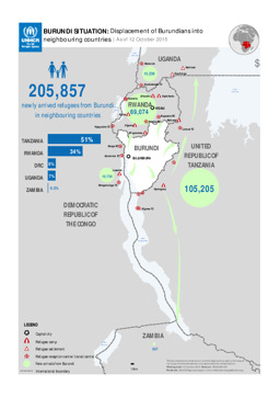
Lagekarte: Landkarte zur Vertreibung von burundischen Flüchtlingen in Nachbarländer (mit Stand von 12. Oktober 2015)
BURUNDI SITUATION: Displacement of Burundians into neighbouring countries; As of 12 October 2015 (Landkarte oder Infografik, Englisch)
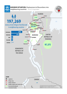
Lagekarte: Landkarte zur Vertreibung von burundischen Flüchtlingen in Nachbarländer (mit Stand von 27. September 2015)
BURUNDI SITUATION: Displacement of Burundians into neighbouring countries; As of 27 September (Landkarte oder Infografik, Englisch)
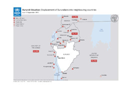
Lagekarte: Landkarte zur Vertreibung burundischer Flüchtlinge in Nachbarstaaten (mit Stand von 13. September 2015)
Burundi Situation: Displacement of Burundians into neighbouring countries; as of 13 September 2015 (Landkarte oder Infografik, Englisch)
Lagekarte: Landkarte zur Herkunft von Vertriebenen (mit Stand von 25. August 2015)
Republique Democratique du Congo Zones de provenance des personnes déplacées des sites de deplacement (Landkarte oder Infografik, Französisch)
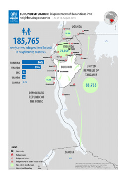
Lagekarte: Landkarte zur Vertreibung burundischer Staatsbürger·innen in Nachbarländer (mit Stand von 13. August 2015)
BURUNDI SITUATION: Displacement of Burundians into neighbouring countries; As of 13 August 2015 (Landkarte oder Infografik, Englisch)
Gefundene Dokumente: 552
