6. August 2015 | UNHCR – UN High Commissioner for Refugees (Autor)
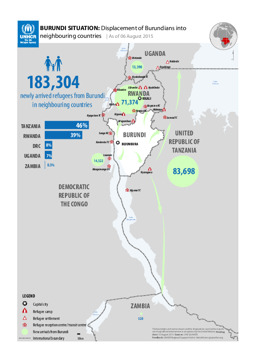
Kongo, Demokratische Republik, Sambia, Tansania, Vereinigte Republik, Uganda
Lagekarte: Landkarte zur Vertreibung burundischer Staatsbürger·innen in Nachbarländer (mit Stand von 6. August 2015)
BURUNDI SITUATION: Displacement of Burundians into neighbouring countries; As of 06 August 2015 (Landkarte oder Infografik, Englisch)
August 2015 | BFA Staatendokumentation (Autor)
Afghanistan, Ägypten, Albanien, Algerien, Angola, Äquatorialguinea, Argentinien, Armenien, Aserbaidschan, Österreich, Äthiopien, Australien, Bahrain, Bangladesch, Belarus, Belgien, Benin, Bhutan, Bolivien, Bosnien und Herzegowina, Botsuana, Brasilien, Bulgarien, Burkina Faso, Burundi, Côte d'Ivoire, Chile, China, Costa Rica, Dänemark, Deutschland, Dominikanische Republik, Dschibuti, Ecuador, El Salvador, Eritrea, Estland, Eswatini, Finnland, Frankreich, Gabun, Gambia, Georgien, Ghana, Griechenland, Guatemala, Guinea, Guinea-Bissau, Haiti, Honduras, Indien, Indonesien, Irak, Iran, Irland, Island, Israel, Italien, Jamaika, Japan, Jemen, Jordanien, Kambodscha, Kamerun, Kanada, Kasachstan, Katar, Kenia, Kirgisistan, Kolumbien, Kongo, Kongo, Demokratische Republik, Korea, Demokratische Volksrepublik, Korea, Republik, Kosovo, Kroatien, Kuba, Kuwait, Laos, Demokratische Volksrepublik, Lesotho, Lettland, Libanon, Liberia, Libyen, Liechtenstein, Litauen, Luxemburg, Madagaskar, Malawi, Malaysia, Malediven, Mali, Malta, Marokko, Mauretanien, Mexiko, Moldau, Republik, Mongolei, Montenegro, Mosambik, Myanmar, Namibia, Nepal, Neuseeland, Nicaragua, Niederlande, Niger, Nigeria, Nordmazedonien, Norwegen, Oman, Pakistan, Palästina, Panama, Paraguay, Peru, Philippinen, Polen, Portugal, Ruanda, Rumänien, Russische Föderation, Südafrika, Südsudan, Sambia, Saudi-Arabien, Schweden, Schweiz, Senegal, Serbien, Sierra Leone, Simbabwe, Singapur, Slowakei, Slowenien, Somalia, Spanien, Sri Lanka, Sudan, Suriname, Syrien, Arabische Republik, Türkei, Tadschikistan, Taiwan, Tansania, Vereinigte Republik, Thailand, Timor-Leste, Togo, Tschad, Tschechische Republik, Tunesien, Turkmenistan, Uganda, Ukraine, Ungarn, Uruguay, Usbekistan, Venezuela, Vereinigte Arabische Emirate, Vereinigtes Königreich, Vereinigte Staaten, Vietnam, Westsahara, Zentralafrikanische Republik, Zypern
Infografiken: Thematischer Atlas zu Demographie und Migration, global und in Europa (Bevölkerungsdichte; Altersstruktur der Bevölkerung; Migration; Vertreibung)
Atlas Demographie & Migration 2015 (Landkarte oder Infografik, Deutsch)
August 2015 | BFA Staatendokumentation (Autor)
Afghanistan, Ägypten, Albanien, Algerien, Angola, Äquatorialguinea, Argentinien, Armenien, Aserbaidschan, Österreich, Äthiopien, Australien, Bahrain, Bangladesch, Belarus, Belgien, Benin, Bhutan, Bolivien, Bosnien und Herzegowina, Botsuana, Brasilien, Bulgarien, Burkina Faso, Burundi, Côte d'Ivoire, Chile, China, Costa Rica, Dänemark, Deutschland, Dominikanische Republik, Dschibuti, Ecuador, El Salvador, Eritrea, Estland, Eswatini, Finnland, Frankreich, Gabun, Gambia, Georgien, Ghana, Griechenland, Guatemala, Guinea, Guinea-Bissau, Haiti, Honduras, Indien, Indonesien, Irak, Iran, Irland, Island, Israel, Italien, Jamaika, Japan, Jemen, Jordanien, Kambodscha, Kamerun, Kanada, Kasachstan, Katar, Kenia, Kirgisistan, Kolumbien, Kongo, Kongo, Demokratische Republik, Korea, Demokratische Volksrepublik, Korea, Republik, Kosovo, Kroatien, Kuba, Kuwait, Laos, Demokratische Volksrepublik, Lesotho, Lettland, Libanon, Liberia, Libyen, Liechtenstein, Litauen, Luxemburg, Madagaskar, Malawi, Malaysia, Malediven, Mali, Malta, Marokko, Mauretanien, Mexiko, Moldau, Republik, Mongolei, Montenegro, Mosambik, Myanmar, Namibia, Nepal, Neuseeland, Nicaragua, Niederlande, Niger, Nigeria, Nordmazedonien, Norwegen, Oman, Pakistan, Palästina, Panama, Paraguay, Peru, Philippinen, Polen, Portugal, Ruanda, Rumänien, Russische Föderation, Südafrika, Südsudan, Sambia, Saudi-Arabien, Schweden, Schweiz, Senegal, Serbien, Sierra Leone, Simbabwe, Singapur, Slowakei, Slowenien, Somalia, Spanien, Sri Lanka, Sudan, Suriname, Syrien, Arabische Republik, Türkei, Tadschikistan, Taiwan, Tansania, Vereinigte Republik, Thailand, Timor-Leste, Togo, Tschad, Tschechische Republik, Tunesien, Turkmenistan, Uganda, Ukraine, Ungarn, Uruguay, Usbekistan, Venezuela, Vereinigte Arabische Emirate, Vereinigtes Königreich, Vereinigte Staaten, Vietnam, Westsahara, Zentralafrikanische Republik, Zypern
Infografiken: Thematischer Atlas zu Demographie und Migration, global und in Europa (Bevölkerungsdichte; Altersstruktur der Bevölkerung; Migration; Vertreibung)
Atlas Demography & Migration 2015 (Landkarte oder Infografik, Englisch)
25. Juli 2015 | UNHCR – UN High Commissioner for Refugees (Autor)
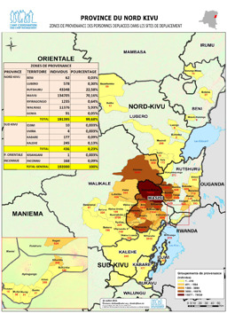
Kongo, Demokratische Republik
Provinz Nordkivu: Lagekarte: Landkarte zur Herkunft von Vertriebenen (mit Stand von 25. Juli 2015)
Province du Nord Kivu; Zones de provenanve des personnes deplacees dans les sites de deplacement (Landkarte oder Infografik, Englisch)
10. Juli 2015 | UNHCR – UN High Commissioner for Refugees (Autor)
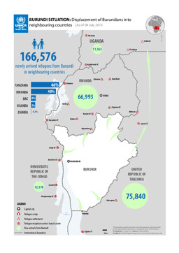
Kongo, Demokratische Republik
Lagekarte: Landkarte zur Vertreibung burundischer Flüchtlinge in Nachbarländer (mit Stand von 8. Juli 2015)
BURUNDI SITUATION: Displacement of Burundians into neighbouring countries | As of 08 July 2015 (Landkarte oder Infografik, Englisch)
30. Juni 2015 | UNHCR – UN High Commissioner for Refugees (Autor)
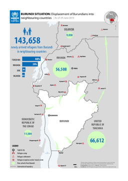
Kongo, Demokratische Republik, Ruanda, Tansania, Vereinigte Republik, Uganda
Lagekarte: Landkarte zur Vertreibung burundischer Staatsbürger·innen in Nachbarländer (mit Stand von 29. Juni 2015)
BURUNDI SITUATION: Displacement of Burundians into neighbouring countries | As of 29 June 2015 (Landkarte oder Infografik, Englisch)
25. Juni 2015 | UNHCR – UN High Commissioner for Refugees (Autor)
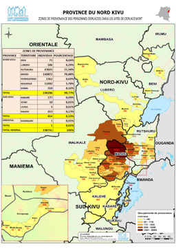
Kongo, Demokratische Republik
Provinz Nordkivu: Lagekarte: Landkarte zur Herkunft von Vertriebenen (mit Stand von 25. Juni 2015)
Province du Nord Kivu; Zones de provenanve des personnes deplacees dans les sites de deplacement; 25 Juin 2015 (Landkarte oder Infografik, Französisch)
25. Juni 2015 | UNHCR – UN High Commissioner for Refugees (Autor)
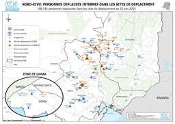
Kongo, Demokratische Republik
Provinz Nordkivu: Lagekarte: Landkarte zu Binnenvertriebenen in Lagern (mit Stand von 25. Juni 2015)
Nord-Kivu; Personnes déplacées internes dans les sites de déplacement; 198,741 personnes déplacées dans les sites de déplacement au 25 juin 2015 (Landkarte oder Infografik, Französisch)
25. Juni 2015 | UNHCR – UN High Commissioner for Refugees (Autor)
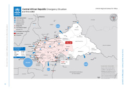
Kamerun, Kongo, Kongo, Demokratische Republik, Tschad, Zentralafrikanische Republik
Lagekarte: Landkarte zu Flüchtlingen sowie Binnenvertriebenen und UNHCR-Stützpunkten in und um die Zentralafrikanische Republik (mit Stand von 25. Juni 2015)
Central African Republic Emergency Sitaution; as of 25 June 2015 (Landkarte oder Infografik, Englisch)
22. Juni 2015 | UNHCR – UN High Commissioner for Refugees (Autor)
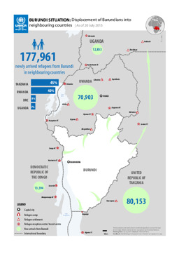
Kongo, Demokratische Republik, Ruanda, Tansania, Vereinigte Republik, Uganda
Lagekarte: Landkarte zur Vertreibung burundischer Flüchtlinge in benachbarte Länder (mit Stand von 20. Juli 2015)
BURUNDI SITUATION: Displacement of Burundians into neighbouring countries; As of 20 July 2015 (Landkarte oder Infografik, Englisch)
