Landkarten
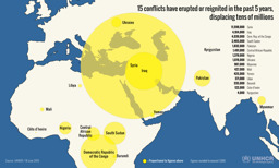
Infografik zu Vertreibung aufgrund von 15 Konflikten während der vorhergehenden 5 Jahre (mit Stand von 18. Juni 2015)
15 conflicts have erupted or reignited in the past 5 years, displacing tens of millions (Landkarte oder Infografik, Englisch)
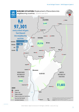
Lagekarte: Landkarte zur Vertreibung burundischer Flüchtlinge in Nachbarländer (mit Stand von 1. Juni 2015)
Burundi Situation: Displacement of Burundians into neighbouring countries; As of 01 June 2015 (Landkarte oder Infografik, Englisch)
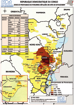
Lagekarte: Landkarte zu Vertreibung nach Territorien (mit Stand von 15. Mai 2015)
Republique Democratique du Congo Zones de provenance des personnes déplacées des sites de deplacement (Landkarte oder Infografik, Französisch)
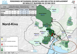
Lagekarte: Landkarte zur Rückkehr/Neubesiedlung in die Städte Nzulo und Buhimba (mit Stand von 25. Mai 2015)
Personnes retournees/reinstallees des sites de deplacement de Nzulo et Buhimba au 25 Mai 2015 (Landkarte oder Infografik, Französisch)
Lagekarte: Landkarte zur Vertreibung burundischer Flüchtlinge in Nachbarländer (mit Stand von 24. Mai 2015)
Burundi Situation: Displacement of Burundians into neighbouring countries; As of 24 May 2015 (Landkarte oder Infografik, Englisch)
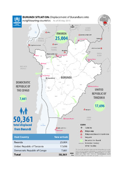
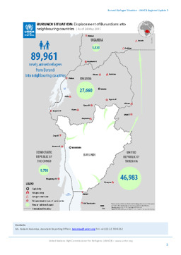
Lagekarte: Landkarte zur Vertreibung burundischer Flüchtlinge in Nachbarländer (mit Stand von 8. Mai 2015)
BURUNDI SITUATION: Displacement of Burundians into neighbouring countries; As of 08 May 2015 (Landkarte oder Infografik, Englisch)
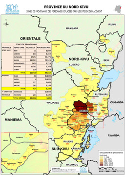
Provinz Nordkivu: Lagekarte: Landkarte zur Herkunft von Binnenvertriebenen (mit Stand von 25. März 2015)
Province du Nord Kivu; Zones de provenanve des personnes deplacees dans les sites de deplacement; 25 March 2015 (Landkarte oder Infografik, Französisch)
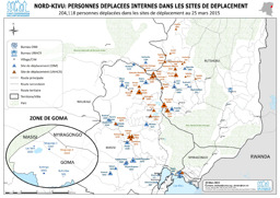
Lagekarte: Landkarte zu Binnenvertriebenen in Lagern (mit Stand von 25. März 2015)
Nord-Kivu; Personnes déplacées internes dans les sites de déplacement; 204,118 personnes déplacées dans les sites de déplacement au 25 mars 2015; 25 March 2015 (Landkarte oder Infografik, Französisch)
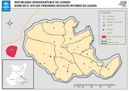
Provinz Nordkivu: Lagekarte: Landkarte zu Binnenvertriebenen in Lusoha
Republique Democratique du Congo; Nord-Kivu: Site des Personnes Deplacées Internes de Lusoha (Landkarte oder Infografik, Französisch)
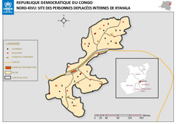
Lagekarte: Landkarte zu Binnenvertriebenen in Kyahala
Republique Democratique du Congo; Nord-Kivu: Site des Personnes Deplacées Internes de Kyahala (Landkarte oder Infografik, Französisch)
Gefundene Dokumente: 552
