Maps
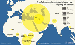
Infographic on the displacement caused by 15 conflicts in the previous 5 years (as of 18 June 2015)
15 conflicts have erupted or reignited in the past 5 years, displacing tens of millions (Map or infographic, English)
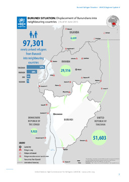
Situation map on the displacement of Burundians into neighbouring countries (as of 1 June 2015)
Burundi Situation: Displacement of Burundians into neighbouring countries; As of 01 June 2015 (Map or infographic, English)
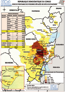
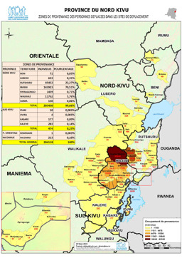
Situation map on displacement by territory (as of 15 May 2015)
Republique Democratique du Congo Zones de provenance des personnes déplacées des sites de deplacement (Map or infographic, French)
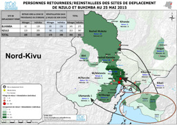
Situation map on repatriation/resettlement to the towns of Nzulo and Buhimba (as of 25 May 2015)
Personnes retournees/reinstallees des sites de deplacement de Nzulo et Buhimba au 25 Mai 2015 (Map or infographic, French)
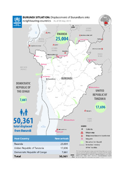
Situation map on the displacement of Burundians into neighbouring countries (as of 24 May 2015)
Burundi Situation: Displacement of Burundians into neighbouring countries; As of 24 May 2015 (Map or infographic, English)
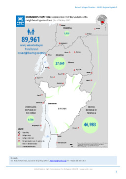
Situation map on the displacement of Burundians into neighbouring countries (as of 8 May 2015)
BURUNDI SITUATION: Displacement of Burundians into neighbouring countries; As of 08 May 2015 (Map or infographic, English)
Nord-Kivu province: Situation map on the provenance of internally displaced (as of 25 March 2015)
Province du Nord Kivu; Zones de provenanve des personnes deplacees dans les sites de deplacement; 25 March 2015 (Map or infographic, French)
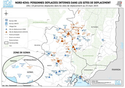
Situation map of IDPs in IDP sites (as of 25 March 2015)
Nord-Kivu; Personnes déplacées internes dans les sites de déplacement; 204,118 personnes déplacées dans les sites de déplacement au 25 mars 2015; 25 March 2015 (Map or infographic, French)
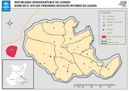
Nord-Kivu province: Situation map on IDPs in Lusoha
Republique Democratique du Congo; Nord-Kivu: Site des Personnes Deplacées Internes de Lusoha (Map or infographic, French)
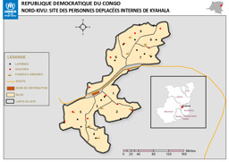
Nord-Kivu province: Situation map on IDPs in Kyahala
Republique Democratique du Congo; Nord-Kivu: Site des Personnes Deplacées Internes de Kyahala (Map or infographic, French)
Documents found: 552
