Maps

Update on conflict-related incidents according to the Armed Conflict Location & Event Data Project (covering second quarter 2014)
Demokratische Republik Kongo, 2. Quartal 2014: Kurzübersicht über Vorfälle aus dem Armed Conflict Location & Event Data Project (ACLED) (Map or infographic, German)
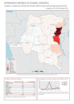
Update on conflict-related incidents according to the Armed Conflict Location & Event Data Project (covering 2014)
Demokratische Republik Kongo, Jahr 2014: Kurzübersicht über Vorfälle aus dem Armed Conflict Location & Event Data Project (ACLED) (Map or infographic, English)
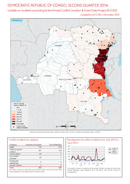
Update on conflict-related incidents according to the Armed Conflict Location & Event Data Project (covering second quarter 2014)
Demokratische Republik Kongo, 2. Quartal 2014: Kurzübersicht über Vorfälle aus dem Armed Conflict Location & Event Data Project (ACLED) (Map or infographic, English)
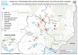
Nord-Kivu province: Situation map on locations of internally displaced people (as of 25 October 2015)
Nord-Kivu; Personnes déplacées internes dans les sites de déplacement (Map or infographic, French)
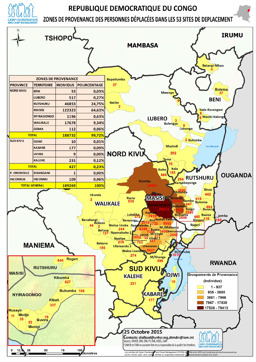
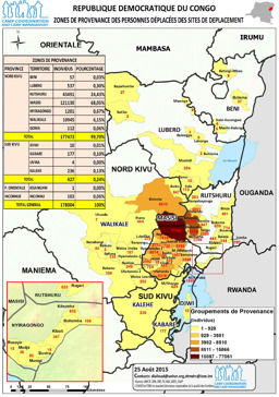
Situation map on places of origin of displaced people (as of 25 October 2015)
Republique Democratique du Congo, Zones de provenance des personnes éplacées dans les 53 sites de deplacement (Map or infographic, French)
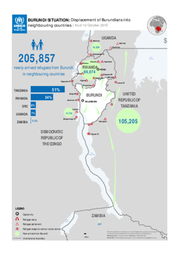
Situation map on the displacement of Burundians into neighbouring countries (as of 12 October 2015)
BURUNDI SITUATION: Displacement of Burundians into neighbouring countries; As of 12 October 2015 (Map or infographic, English)
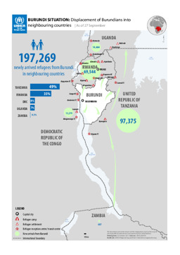
Situation map on the displacement of Burundians into neighbouring counties (as of 27 September 2015)
BURUNDI SITUATION: Displacement of Burundians into neighbouring countries; As of 27 September (Map or infographic, English)
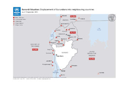
Situation map on the displacement of Burundians into neighbouring countries (as of 13 September 2015)
Burundi Situation: Displacement of Burundians into neighbouring countries; as of 13 September 2015 (Map or infographic, English)
Situation map on places of origin of displaced people (as of 25 August 2015)
Republique Democratique du Congo Zones de provenance des personnes déplacées des sites de deplacement (Map or infographic, French)
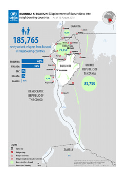
Situation map on the displacement of Burundians into neigbouring countries (as of 13 August 2015)
BURUNDI SITUATION: Displacement of Burundians into neighbouring countries; As of 13 August 2015 (Map or infographic, English)
Documents found: 552
