3. November 2015 | ACCORD – Austrian Centre for Country of Origin and Asylum Research and Documentation (Autor)
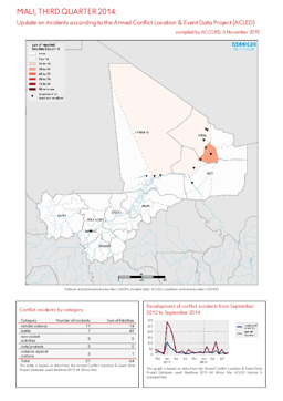
Mali
Kurzübersicht über Konfliktvorfälle aus dem Armed Conflict Location & Event Data Project (Berichtszeitraum 3. Quartal 2014)
Mali, 3. Quartal 2014: Kurzübersicht über Vorfälle aus dem Armed Conflict Location & Event Data Project (ACLED) (Landkarte oder Infografik, Englisch)
3. November 2015 | ACCORD – Austrian Centre for Country of Origin and Asylum Research and Documentation (Autor)
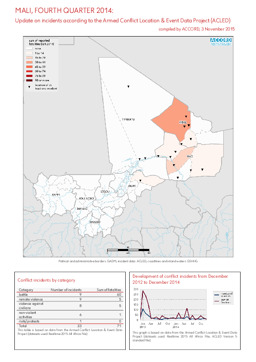
Mali
Kurzübersicht über Konfliktvorfälle aus dem Armed Conflict Location & Event Data Project (Berichtszeitraum 4. Quartal 2014)
Mali, 4. Quartal 2014: Kurzübersicht über Vorfälle aus dem Armed Conflict Location & Event Data Project (ACLED) (Landkarte oder Infografik, Englisch)
3. November 2015 | ACCORD – Austrian Centre for Country of Origin and Asylum Research and Documentation (Autor)
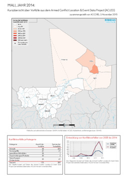
Mali
Kurzübersicht über Konfliktvorfälle aus dem Armed Conflict Location & Event Data Project (Berichtszeitraum Jahr 2014)
Mali, Jahr 2014: Kurzübersicht über Vorfälle aus dem Armed Conflict Location & Event Data Project (ACLED) (Landkarte oder Infografik, Deutsch)
August 2015 | BFA Staatendokumentation (Autor)
Afghanistan, Ägypten, Albanien, Algerien, Angola, Äquatorialguinea, Argentinien, Armenien, Aserbaidschan, Österreich, Äthiopien, Australien, Bahrain, Bangladesch, Belarus, Belgien, Benin, Bhutan, Bolivien, Bosnien und Herzegowina, Botsuana, Brasilien, Bulgarien, Burkina Faso, Burundi, Côte d'Ivoire, Chile, China, Costa Rica, Dänemark, Deutschland, Dominikanische Republik, Dschibuti, Ecuador, El Salvador, Eritrea, Estland, Eswatini, Finnland, Frankreich, Gabun, Gambia, Georgien, Ghana, Griechenland, Guatemala, Guinea, Guinea-Bissau, Haiti, Honduras, Indien, Indonesien, Irak, Iran, Irland, Island, Israel, Italien, Jamaika, Japan, Jemen, Jordanien, Kambodscha, Kamerun, Kanada, Kasachstan, Katar, Kenia, Kirgisistan, Kolumbien, Kongo, Kongo, Demokratische Republik, Korea, Demokratische Volksrepublik, Korea, Republik, Kosovo, Kroatien, Kuba, Kuwait, Laos, Demokratische Volksrepublik, Lesotho, Lettland, Libanon, Liberia, Libyen, Liechtenstein, Litauen, Luxemburg, Madagaskar, Malawi, Malaysia, Malediven, Mali, Malta, Marokko, Mauretanien, Mexiko, Moldau, Republik, Mongolei, Montenegro, Mosambik, Myanmar, Namibia, Nepal, Neuseeland, Nicaragua, Niederlande, Niger, Nigeria, Nordmazedonien, Norwegen, Oman, Pakistan, Palästina, Panama, Paraguay, Peru, Philippinen, Polen, Portugal, Ruanda, Rumänien, Russische Föderation, Südafrika, Südsudan, Sambia, Saudi-Arabien, Schweden, Schweiz, Senegal, Serbien, Sierra Leone, Simbabwe, Singapur, Slowakei, Slowenien, Somalia, Spanien, Sri Lanka, Sudan, Suriname, Syrien, Arabische Republik, Türkei, Tadschikistan, Taiwan, Tansania, Vereinigte Republik, Thailand, Timor-Leste, Togo, Tschad, Tschechische Republik, Tunesien, Turkmenistan, Uganda, Ukraine, Ungarn, Uruguay, Usbekistan, Venezuela, Vereinigte Arabische Emirate, Vereinigtes Königreich, Vereinigte Staaten, Vietnam, Westsahara, Zentralafrikanische Republik, Zypern
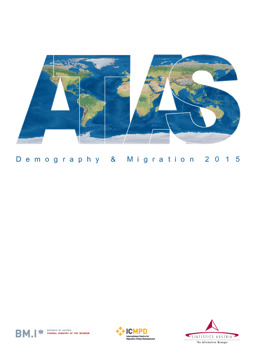
Infografiken: Thematischer Atlas zu Demographie und Migration, global und in Europa (Bevölkerungsdichte; Altersstruktur der Bevölkerung; Migration; Vertreibung)
Atlas Demographie & Migration 2015 (Landkarte oder Infografik, Deutsch)
August 2015 | BFA Staatendokumentation (Autor)
Afghanistan, Ägypten, Albanien, Algerien, Angola, Äquatorialguinea, Argentinien, Armenien, Aserbaidschan, Österreich, Äthiopien, Australien, Bahrain, Bangladesch, Belarus, Belgien, Benin, Bhutan, Bolivien, Bosnien und Herzegowina, Botsuana, Brasilien, Bulgarien, Burkina Faso, Burundi, Côte d'Ivoire, Chile, China, Costa Rica, Dänemark, Deutschland, Dominikanische Republik, Dschibuti, Ecuador, El Salvador, Eritrea, Estland, Eswatini, Finnland, Frankreich, Gabun, Gambia, Georgien, Ghana, Griechenland, Guatemala, Guinea, Guinea-Bissau, Haiti, Honduras, Indien, Indonesien, Irak, Iran, Irland, Island, Israel, Italien, Jamaika, Japan, Jemen, Jordanien, Kambodscha, Kamerun, Kanada, Kasachstan, Katar, Kenia, Kirgisistan, Kolumbien, Kongo, Kongo, Demokratische Republik, Korea, Demokratische Volksrepublik, Korea, Republik, Kosovo, Kroatien, Kuba, Kuwait, Laos, Demokratische Volksrepublik, Lesotho, Lettland, Libanon, Liberia, Libyen, Liechtenstein, Litauen, Luxemburg, Madagaskar, Malawi, Malaysia, Malediven, Mali, Malta, Marokko, Mauretanien, Mexiko, Moldau, Republik, Mongolei, Montenegro, Mosambik, Myanmar, Namibia, Nepal, Neuseeland, Nicaragua, Niederlande, Niger, Nigeria, Nordmazedonien, Norwegen, Oman, Pakistan, Palästina, Panama, Paraguay, Peru, Philippinen, Polen, Portugal, Ruanda, Rumänien, Russische Föderation, Südafrika, Südsudan, Sambia, Saudi-Arabien, Schweden, Schweiz, Senegal, Serbien, Sierra Leone, Simbabwe, Singapur, Slowakei, Slowenien, Somalia, Spanien, Sri Lanka, Sudan, Suriname, Syrien, Arabische Republik, Türkei, Tadschikistan, Taiwan, Tansania, Vereinigte Republik, Thailand, Timor-Leste, Togo, Tschad, Tschechische Republik, Tunesien, Turkmenistan, Uganda, Ukraine, Ungarn, Uruguay, Usbekistan, Venezuela, Vereinigte Arabische Emirate, Vereinigtes Königreich, Vereinigte Staaten, Vietnam, Westsahara, Zentralafrikanische Republik, Zypern
Infografiken: Thematischer Atlas zu Demographie und Migration, global und in Europa (Bevölkerungsdichte; Altersstruktur der Bevölkerung; Migration; Vertreibung)
Atlas Demography & Migration 2015 (Landkarte oder Infografik, Englisch)
18. Juni 2015 | UNHCR – UN High Commissioner for Refugees (Autor)
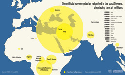
Burundi, Côte d'Ivoire, Irak, Jemen, Kirgisistan, Kongo, Demokratische Republik, Libyen, Mali, Myanmar, Nigeria, Pakistan, Südsudan, Syrien, Arabische Republik, Ukraine, Zentralafrikanische Republik
Infografik zu Vertreibung aufgrund von 15 Konflikten während der vorhergehenden 5 Jahre (mit Stand von 18. Juni 2015)
15 conflicts have erupted or reignited in the past 5 years, displacing tens of millions (Landkarte oder Infografik, Englisch)
9. Juni 2015 | UNHCR – UN High Commissioner for Refugees (Autor)
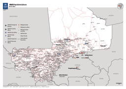
Mali
Karte zu Einrichtungen des UNHCR und zum Straßennetz
Mali: Populated places - 09 Jun 2015 (Landkarte oder Infografik, Englisch)
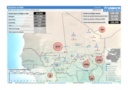
26. Mai 2015 | UNHCR – UN High Commissioner for Refugees (Autor)
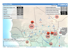
Algerien, Burkina Faso, Guinea, Mali, Mauretanien, Niger, Togo
Lagekarte: Landkarte zur Verteilung von Flüchtlingen, Rückkehrer·innen und Binnenvertriebenen in und um Mali (mit Stand von 26. Mai 2015)
Situation au Mali - Réfugiés, rapatriés et personnes déplacées internes au Mali (Landkarte oder Infografik, Französisch)
31. August 2014 | UNHCR – UN High Commissioner for Refugees (Autor)
Burkina Faso, Côte d'Ivoire, Guinea, Mali, Mauretanien, Niger, Togo, Zentralafrikanische Republik
Lagekarte: Landkarte zu Vertreibung (Verteilung von Flüchtlingen und Binnenvertriebenen) (mit Stand von 31. August 2014)
Situation au Mali; Réfugiés, rapatriés et personnes déplacées internes au Mali; 31 août 2014 (Landkarte oder Infografik, Englisch)
31. Juli 2014 | UNHCR – UN High Commissioner for Refugees (Autor)
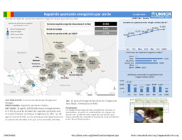
Algerien, Burkina Faso, Ghana, Guinea, Mali, Mauretanien, Niger
Infografik zu seit August 2013 verzeichneten Fällen von spontaner Rückkehr nach Mali (mit Stand von 31. Juli 2014)
Rapatriés spontanés enregistrés par cercle; 31 juillet 2014 (Landkarte oder Infografik, Französisch)
