31. Oktober 2017 | UNHCR – UN High Commissioner for Refugees (Autor)
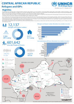
Kamerun, Kongo, Kongo, Demokratische Republik, Südsudan, Sudan, Tschad, Zentralafrikanische Republik
Lagekarte: Landkarte zur Verteilung von Binnenvertriebenen in der Zentralafrikanischen Republik und von Flüchtlingen aus der Zentralafrikanischen Republik in benachbarten Ländern (mit Stand von 31. Oktober 2017)
Central African Republic; Refugees and IDPs; Situation as of 31 October 2017 (Landkarte oder Infografik, Englisch)
28. April 2016 | UNHCR – UN High Commissioner for Refugees (Autor)
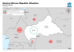
Kamerun, Kongo, Kongo, Demokratische Republik, Tschad, Zentralafrikanische Republik
Lagekarte: Landkarte zu Binnenvertriebenen in der Zentralafrikanischen Republik und zu Flüchtlingen aus der Zentralafrikanischen Republik in benachbarten Ländern (mit Stand von 28. April 2016)
Central African Republic Situation; Regional Overview; as of 28 Apr 2016 (Landkarte oder Infografik, Englisch)
27. Jänner 2016 | UNHCR – UN High Commissioner for Refugees (Autor)
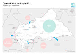
Kamerun, Kongo, Kongo, Demokratische Republik, Tschad, Zentralafrikanische Republik
Lagekarte: Landkarte zu Flüchtlingen sowie Binnenvertriebenen und UNHCR-Stützpunkten in und um die Zentralafrikanische Republik (mit Stand von 31. Dezember 2015)
Central African Republic - Situation: IDPs and Refugees; as of 31 Dec 2015 (Landkarte oder Infografik, Englisch)
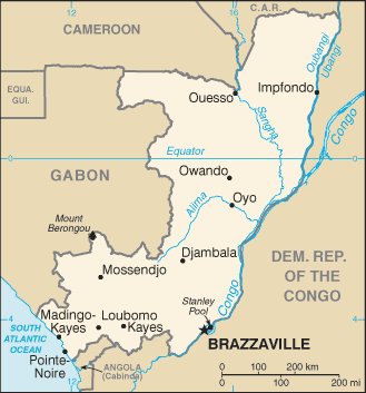
2016 | CIA – Central Intelligence Agency (Autor), veröffentlicht von University of Texas Libraries
Kongo
Kleine Landkarte der Republik Kongo
Congo, Republic of the (Small Map) 2016 (Landkarte oder Infografik, Englisch)
August 2015 | BFA Staatendokumentation (Autor)
Afghanistan, Ägypten, Albanien, Algerien, Angola, Äquatorialguinea, Argentinien, Armenien, Aserbaidschan, Österreich, Äthiopien, Australien, Bahrain, Bangladesch, Belarus, Belgien, Benin, Bhutan, Bolivien, Bosnien und Herzegowina, Botsuana, Brasilien, Bulgarien, Burkina Faso, Burundi, Côte d'Ivoire, Chile, China, Costa Rica, Dänemark, Deutschland, Dominikanische Republik, Dschibuti, Ecuador, El Salvador, Eritrea, Estland, Eswatini, Finnland, Frankreich, Gabun, Gambia, Georgien, Ghana, Griechenland, Guatemala, Guinea, Guinea-Bissau, Haiti, Honduras, Indien, Indonesien, Irak, Iran, Irland, Island, Israel, Italien, Jamaika, Japan, Jemen, Jordanien, Kambodscha, Kamerun, Kanada, Kasachstan, Katar, Kenia, Kirgisistan, Kolumbien, Kongo, Kongo, Demokratische Republik, Korea, Demokratische Volksrepublik, Korea, Republik, Kosovo, Kroatien, Kuba, Kuwait, Laos, Demokratische Volksrepublik, Lesotho, Lettland, Libanon, Liberia, Libyen, Liechtenstein, Litauen, Luxemburg, Madagaskar, Malawi, Malaysia, Malediven, Mali, Malta, Marokko, Mauretanien, Mexiko, Moldau, Republik, Mongolei, Montenegro, Mosambik, Myanmar, Namibia, Nepal, Neuseeland, Nicaragua, Niederlande, Niger, Nigeria, Nordmazedonien, Norwegen, Oman, Pakistan, Palästina, Panama, Paraguay, Peru, Philippinen, Polen, Portugal, Ruanda, Rumänien, Russische Föderation, Südafrika, Südsudan, Sambia, Saudi-Arabien, Schweden, Schweiz, Senegal, Serbien, Sierra Leone, Simbabwe, Singapur, Slowakei, Slowenien, Somalia, Spanien, Sri Lanka, Sudan, Suriname, Syrien, Arabische Republik, Türkei, Tadschikistan, Taiwan, Tansania, Vereinigte Republik, Thailand, Timor-Leste, Togo, Tschad, Tschechische Republik, Tunesien, Turkmenistan, Uganda, Ukraine, Ungarn, Uruguay, Usbekistan, Venezuela, Vereinigte Arabische Emirate, Vereinigtes Königreich, Vereinigte Staaten, Vietnam, Westsahara, Zentralafrikanische Republik, Zypern
Infografiken: Thematischer Atlas zu Demographie und Migration, global und in Europa (Bevölkerungsdichte; Altersstruktur der Bevölkerung; Migration; Vertreibung)
Atlas Demographie & Migration 2015 (Landkarte oder Infografik, Deutsch)
August 2015 | BFA Staatendokumentation (Autor)
Afghanistan, Ägypten, Albanien, Algerien, Angola, Äquatorialguinea, Argentinien, Armenien, Aserbaidschan, Österreich, Äthiopien, Australien, Bahrain, Bangladesch, Belarus, Belgien, Benin, Bhutan, Bolivien, Bosnien und Herzegowina, Botsuana, Brasilien, Bulgarien, Burkina Faso, Burundi, Côte d'Ivoire, Chile, China, Costa Rica, Dänemark, Deutschland, Dominikanische Republik, Dschibuti, Ecuador, El Salvador, Eritrea, Estland, Eswatini, Finnland, Frankreich, Gabun, Gambia, Georgien, Ghana, Griechenland, Guatemala, Guinea, Guinea-Bissau, Haiti, Honduras, Indien, Indonesien, Irak, Iran, Irland, Island, Israel, Italien, Jamaika, Japan, Jemen, Jordanien, Kambodscha, Kamerun, Kanada, Kasachstan, Katar, Kenia, Kirgisistan, Kolumbien, Kongo, Kongo, Demokratische Republik, Korea, Demokratische Volksrepublik, Korea, Republik, Kosovo, Kroatien, Kuba, Kuwait, Laos, Demokratische Volksrepublik, Lesotho, Lettland, Libanon, Liberia, Libyen, Liechtenstein, Litauen, Luxemburg, Madagaskar, Malawi, Malaysia, Malediven, Mali, Malta, Marokko, Mauretanien, Mexiko, Moldau, Republik, Mongolei, Montenegro, Mosambik, Myanmar, Namibia, Nepal, Neuseeland, Nicaragua, Niederlande, Niger, Nigeria, Nordmazedonien, Norwegen, Oman, Pakistan, Palästina, Panama, Paraguay, Peru, Philippinen, Polen, Portugal, Ruanda, Rumänien, Russische Föderation, Südafrika, Südsudan, Sambia, Saudi-Arabien, Schweden, Schweiz, Senegal, Serbien, Sierra Leone, Simbabwe, Singapur, Slowakei, Slowenien, Somalia, Spanien, Sri Lanka, Sudan, Suriname, Syrien, Arabische Republik, Türkei, Tadschikistan, Taiwan, Tansania, Vereinigte Republik, Thailand, Timor-Leste, Togo, Tschad, Tschechische Republik, Tunesien, Turkmenistan, Uganda, Ukraine, Ungarn, Uruguay, Usbekistan, Venezuela, Vereinigte Arabische Emirate, Vereinigtes Königreich, Vereinigte Staaten, Vietnam, Westsahara, Zentralafrikanische Republik, Zypern
Infografiken: Thematischer Atlas zu Demographie und Migration, global und in Europa (Bevölkerungsdichte; Altersstruktur der Bevölkerung; Migration; Vertreibung)
Atlas Demography & Migration 2015 (Landkarte oder Infografik, Englisch)
25. Juni 2015 | UNHCR – UN High Commissioner for Refugees (Autor)
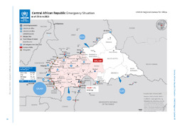
Kamerun, Kongo, Kongo, Demokratische Republik, Tschad, Zentralafrikanische Republik
Lagekarte: Landkarte zu Flüchtlingen sowie Binnenvertriebenen und UNHCR-Stützpunkten in und um die Zentralafrikanische Republik (mit Stand von 25. Juni 2015)
Central African Republic Emergency Sitaution; as of 25 June 2015 (Landkarte oder Infografik, Englisch)
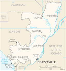
2013 | U.S. Central Intelligence Agency (Autor), veröffentlicht von University of Texas Libraries
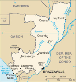
Kongo
Kleine Landkarte
Congo, Republic of the (Small Map) 2013 (Landkarte oder Infografik, Englisch)
3. Mai 2010 | USAID – US Agency for International Development (Autor)
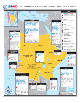
Äthiopien, Burundi, Dschibuti, Eritrea, Kenia, Kongo, Kongo, Demokratische Republik, Ruanda, Somalia, Sudan, Tansania, Vereinigte Republik, Tschad, Uganda, Zentralafrikanische Republik
Lagekarte: Landkarte zu humanitärer Hilfe durch USAID (mit Stand 3. Mai 2010)
USG Humanitarian Assistance to East and Central Africa (Landkarte oder Infografik, Englisch)
September 2009 | IDMC – Internal Displacement Monitoring Centre (ehemals: Global IDP Project) (Autor)
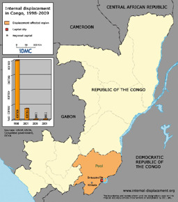
Kongo
Landkarte zu Binnenvertreibung im Kongo (1998-2009)
Internal displacement in Congo, 1998-2009 (Landkarte oder Infografik, Englisch)