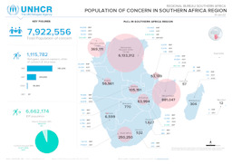
31. Mai 2023 | UNHCR – UN High Commissioner for Refugees (Autor)
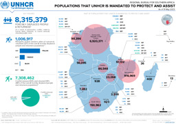
Angola, Botsuana, Eswatini, Kongo, Kongo, Demokratische Republik, Lesotho, Madagaskar, Malawi, Mosambik, Namibia, Südafrika, Sambia, Simbabwe
Infografik zur Verteilung von Flüchtlingen, Asylwerber·innen, Binnenvertriebenen und Rückkehrer·innen (mit Stand von 31. Mai 2023)
Regional Bureau for Southern Africa; Populations that UNHCR is Mandated to Protect and Assist; As of 31 May 2023 (Landkarte oder Infografik, Englisch)
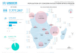
31. Juli 2022 | UNHCR – UN High Commissioner for Refugees (Autor)
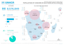
Angola, Botsuana, Eswatini, Kongo, Kongo, Demokratische Republik, Lesotho, Madagaskar, Malawi, Mosambik, Namibia, Südafrika, Sambia, Simbabwe
Infografik zu Vertreibung in der Region des südlichen Afrika (Verteilung von Flüchtlingen; Verteilung von Asylwerber·innen; Verteilung von Binnenvertriebenen) (mit Stand von 31. Juli 2022)
Regional Bureau for Southern Africa; Population of Concern in Southern Africa Region; 31-July-2022 (Landkarte oder Infografik, Englisch)
31. Mai 2022 | UNHCR – UN High Commissioner for Refugees (Autor)
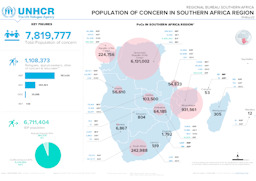
Angola, Botsuana, Eswatini, Kongo, Kongo, Demokratische Republik, Lesotho, Madagaskar, Malawi, Mosambik, Namibia, Südafrika, Sambia, Simbabwe
Infografik zu Vertreibung in der Region des südlichen Afrika (Verteilung von Flüchtlingen; Verteilung von Asylwerber·innen; Verteilung von Binnenvertriebenen) (mit Stand von 31. Mai 2022)
Regional Bureau Southern Africa; Population of Concern in Southern Africa Region; 31-May-22 (Landkarte oder Infografik, Englisch)
28. Februar 2022 | UNHCR – UN High Commissioner for Refugees (Autor), veröffentlicht von ReliefWeb
Angola, Botsuana, Eswatini, Kongo, Kongo, Demokratische Republik, Lesotho, Madagaskar, Malawi, Mosambik, Namibia, Südafrika, Sambia, Simbabwe
Infografik zu Vertreibung in der Region des südlichen Afrika (Verteilung von Flüchtlingen; Verteilung von Asylwerber·innen; Verteilung von Binnenvertriebenen) (mit Stand von 28. Februar 2022)
Regional Bureau Southern Africa; Population of Concern in Southern Africa Region; 28-Feb-22 (Landkarte oder Infografik, Englisch)
31. Jänner 2022 | UNHCR – UN High Commissioner for Refugees (Autor)
Angola, Botsuana, Eswatini, Kongo, Kongo, Demokratische Republik, Lesotho, Madagaskar, Malawi, Mosambik, Namibia, Südafrika, Sambia, Simbabwe
Infografik zu Vertreibung in der Region des südlichen Afrika (Verteilung von Flüchtlingen; Verteilung von Asylwerber·innen; Verteilung von Binnenvertriebenen) (mit Stand von 31. Jänner 2022)
Regional Bureau Southern Africa; Population of Concern in Southern Africa Region; 31-Jan-22 (Landkarte oder Infografik, Englisch)
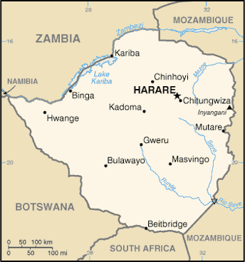
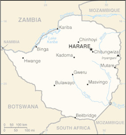
Dezember 2017 | UN Cartographic Section (Autor)
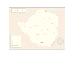
Simbabwe
Landkarte von Simbabwe
Zimbabwe (Landkarte oder Infografik, Englisch)
9. Februar 2017 | UNHCR – UN High Commissioner for Refugees (Autor)
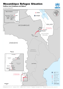
Malawi, Mosambik, Simbabwe
Karte zu Bevölkerungsbewegungen aus Mosambik nach Simbabwe und Malawi
Mozambique Refugee Situation; Outflow into Zimbabwe and Malawi; as of end of January 2017 (Landkarte oder Infografik, Englisch)
2016 | CIA – Central Intelligence Agency (Autor), veröffentlicht von University of Texas Libraries
Simbabwe
Kleine Landkarte von Simbabwe
Zimbabwe (Small Map) 2016 (Landkarte oder Infografik, Englisch)
August 2015 | BFA Staatendokumentation (Autor)
Afghanistan, Ägypten, Albanien, Algerien, Angola, Äquatorialguinea, Argentinien, Armenien, Aserbaidschan, Österreich, Äthiopien, Australien, Bahrain, Bangladesch, Belarus, Belgien, Benin, Bhutan, Bolivien, Bosnien und Herzegowina, Botsuana, Brasilien, Bulgarien, Burkina Faso, Burundi, Côte d'Ivoire, Chile, China, Costa Rica, Dänemark, Deutschland, Dominikanische Republik, Dschibuti, Ecuador, El Salvador, Eritrea, Estland, Eswatini, Finnland, Frankreich, Gabun, Gambia, Georgien, Ghana, Griechenland, Guatemala, Guinea, Guinea-Bissau, Haiti, Honduras, Indien, Indonesien, Irak, Iran, Irland, Island, Israel, Italien, Jamaika, Japan, Jemen, Jordanien, Kambodscha, Kamerun, Kanada, Kasachstan, Katar, Kenia, Kirgisistan, Kolumbien, Kongo, Kongo, Demokratische Republik, Korea, Demokratische Volksrepublik, Korea, Republik, Kosovo, Kroatien, Kuba, Kuwait, Laos, Demokratische Volksrepublik, Lesotho, Lettland, Libanon, Liberia, Libyen, Liechtenstein, Litauen, Luxemburg, Madagaskar, Malawi, Malaysia, Malediven, Mali, Malta, Marokko, Mauretanien, Mexiko, Moldau, Republik, Mongolei, Montenegro, Mosambik, Myanmar, Namibia, Nepal, Neuseeland, Nicaragua, Niederlande, Niger, Nigeria, Nordmazedonien, Norwegen, Oman, Pakistan, Palästina, Panama, Paraguay, Peru, Philippinen, Polen, Portugal, Ruanda, Rumänien, Russische Föderation, Südafrika, Südsudan, Sambia, Saudi-Arabien, Schweden, Schweiz, Senegal, Serbien, Sierra Leone, Simbabwe, Singapur, Slowakei, Slowenien, Somalia, Spanien, Sri Lanka, Sudan, Suriname, Syrien, Arabische Republik, Türkei, Tadschikistan, Taiwan, Tansania, Vereinigte Republik, Thailand, Timor-Leste, Togo, Tschad, Tschechische Republik, Tunesien, Turkmenistan, Uganda, Ukraine, Ungarn, Uruguay, Usbekistan, Venezuela, Vereinigte Arabische Emirate, Vereinigtes Königreich, Vereinigte Staaten, Vietnam, Westsahara, Zentralafrikanische Republik, Zypern
Infografiken: Thematischer Atlas zu Demographie und Migration, global und in Europa (Bevölkerungsdichte; Altersstruktur der Bevölkerung; Migration; Vertreibung)
Atlas Demographie & Migration 2015 (Landkarte oder Infografik, Deutsch)
August 2015 | BFA Staatendokumentation (Autor)
Afghanistan, Ägypten, Albanien, Algerien, Angola, Äquatorialguinea, Argentinien, Armenien, Aserbaidschan, Österreich, Äthiopien, Australien, Bahrain, Bangladesch, Belarus, Belgien, Benin, Bhutan, Bolivien, Bosnien und Herzegowina, Botsuana, Brasilien, Bulgarien, Burkina Faso, Burundi, Côte d'Ivoire, Chile, China, Costa Rica, Dänemark, Deutschland, Dominikanische Republik, Dschibuti, Ecuador, El Salvador, Eritrea, Estland, Eswatini, Finnland, Frankreich, Gabun, Gambia, Georgien, Ghana, Griechenland, Guatemala, Guinea, Guinea-Bissau, Haiti, Honduras, Indien, Indonesien, Irak, Iran, Irland, Island, Israel, Italien, Jamaika, Japan, Jemen, Jordanien, Kambodscha, Kamerun, Kanada, Kasachstan, Katar, Kenia, Kirgisistan, Kolumbien, Kongo, Kongo, Demokratische Republik, Korea, Demokratische Volksrepublik, Korea, Republik, Kosovo, Kroatien, Kuba, Kuwait, Laos, Demokratische Volksrepublik, Lesotho, Lettland, Libanon, Liberia, Libyen, Liechtenstein, Litauen, Luxemburg, Madagaskar, Malawi, Malaysia, Malediven, Mali, Malta, Marokko, Mauretanien, Mexiko, Moldau, Republik, Mongolei, Montenegro, Mosambik, Myanmar, Namibia, Nepal, Neuseeland, Nicaragua, Niederlande, Niger, Nigeria, Nordmazedonien, Norwegen, Oman, Pakistan, Palästina, Panama, Paraguay, Peru, Philippinen, Polen, Portugal, Ruanda, Rumänien, Russische Föderation, Südafrika, Südsudan, Sambia, Saudi-Arabien, Schweden, Schweiz, Senegal, Serbien, Sierra Leone, Simbabwe, Singapur, Slowakei, Slowenien, Somalia, Spanien, Sri Lanka, Sudan, Suriname, Syrien, Arabische Republik, Türkei, Tadschikistan, Taiwan, Tansania, Vereinigte Republik, Thailand, Timor-Leste, Togo, Tschad, Tschechische Republik, Tunesien, Turkmenistan, Uganda, Ukraine, Ungarn, Uruguay, Usbekistan, Venezuela, Vereinigte Arabische Emirate, Vereinigtes Königreich, Vereinigte Staaten, Vietnam, Westsahara, Zentralafrikanische Republik, Zypern
Infografiken: Thematischer Atlas zu Demographie und Migration, global und in Europa (Bevölkerungsdichte; Altersstruktur der Bevölkerung; Migration; Vertreibung)
Atlas Demography & Migration 2015 (Landkarte oder Infografik, Englisch)