Maps
Update on conflict-related incidents according to the Armed Conflict Location & Event Data Project (covering second quarter 2015)
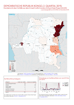
Demokratische Republik Kongo, 2. Quartal 2015: Kurzübersicht über Vorfälle aus dem Armed Conflict Location & Event Data Project (ACLED) (Map or infographic, German)
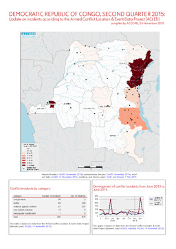
Update on conflict-related incidents according to the Armed Conflict Location & Event Data Project (covering second quarter 2015)
Demokratische Republik Kongo, 2. Quartal 2015: Kurzübersicht über Vorfälle aus dem Armed Conflict Location & Event Data Project (ACLED) (Map or infographic, English)
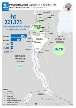
Situation map on the displacement of Burundians into neighbouring counties (as of 17 November 2015)
Burundi Situation: Displacement of Burundians into neigbouring countries; As of 17 November 2015 (Map or infographic, English)
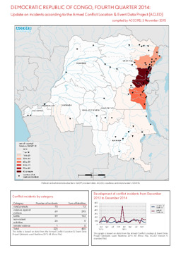
Update on conflict-related incidents according to the Armed Conflict Location & Event Data Project (covering fourth quarter 2014)
Demokratische Republik Kongo, 4. Quartal 2014: Kurzübersicht über Vorfälle aus dem Armed Conflict Location & Event Data Project (ACLED) (Map or infographic, English)
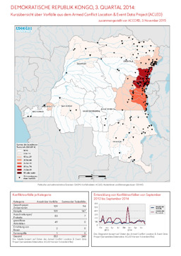
Update on conflict-related incidents according to the Armed Conflict Location & Event Data Project (covering third quarter 2014)
Demokratische Republik Kongo, 3. Quartal 2014: Kurzübersicht über Vorfälle aus dem Armed Conflict Location & Event Data Project (ACLED) (Map or infographic, German)
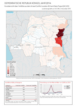
Update on conflict-related incidents according to the Armed Conflict Location & Event Data Project (covering 2014)
Demokratische Republik Kongo, Jahr 2014: Kurzübersicht über Vorfälle aus dem Armed Conflict Location & Event Data Project (ACLED) (Map or infographic, German)
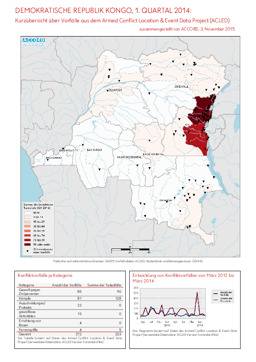
Update on conflict-related incidents according to the Armed Conflict Location & Event Data Project (covering first quarter 2014)
Demokratische Republik Kongo, 1. Quartal 2014: Kurzübersicht über Vorfälle aus dem Armed Conflict Location & Event Data Project (ACLED) (Map or infographic, German)
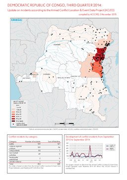
Update on conflict-related incidents according to the Armed Conflict Location & Event Data Project (covering third quarter 2014)
Demokratische Republik Kongo, 3. Quartal 2014: Kurzübersicht über Vorfälle aus dem Armed Conflict Location & Event Data Project (ACLED) (Map or infographic, English)
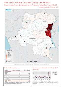
Update on conflict-related incidents according to the Armed Conflict Location & Event Data Project (covering first quarter 2014)
Demokratische Republik Kongo, 1. Quartal 2014: Kurzübersicht über Vorfälle aus dem Armed Conflict Location & Event Data Project (ACLED) (Map or infographic, English)
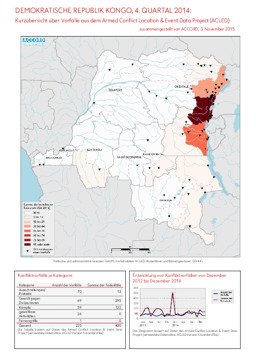
Update on conflict-related incidents according to the Armed Conflict Location & Event Data Project (covering fourth quarter 2014)
Demokratische Republik Kongo, 4. Quartal 2014: Kurzübersicht über Vorfälle aus dem Armed Conflict Location & Event Data Project (ACLED) (Map or infographic, German)
Documents found: 552
