Maps
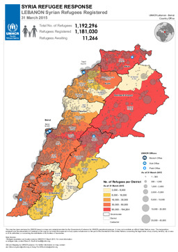
Situation map on displacement (distribution of registered Syrian refugees in Lebanon) (as of 31 March 2015)
Syria Refugee Response - Lebanon Syrian Refugees Registered; 31 March 2015 (Map or infographic, English)
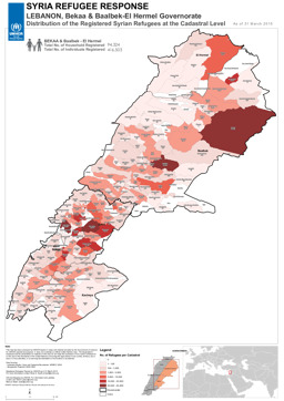
Situation map on displacement (distribution of registered Syrian refugees in the Bekaa and Baalbek-El Hemel governorates) (as of 31 March 2015)
Syria Refugee Response - Lebanon: Bekaa and Baalbek-El Hermel Governorate - Distribution of the Registered Syrian Refugees at the Cadastral Level; As of 31 March 2015 (Map or infographic, English)
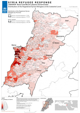
Situation map on displacement (distribution of registered Syrian refugees in the Beirut and Mount Lebanon governorates) (as of 31 March 2015)
Syria Refugee Response - Lebanon, Beirut and Mount Lebanon Governates - Distribution of the Registered Refugees at the Cadastral Level; As of 31 March 2015 (Map or infographic, English)
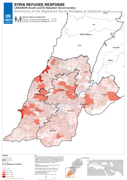
Situation map on displacement (distribution of registered Syrian refugees in the South and El Nabatieh Governorates) (as of 31 March 2015)
Syria Refugee Response - Lebanon: South and El Nabatieh Governorates - Distribution of the Registered Syrian Refugees at the Cadastral Level; As of 31 March 2015 (Map or infographic, English)
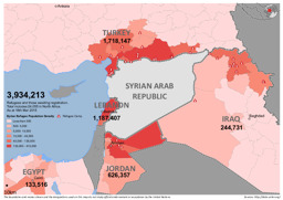
Situation map on the distribution of Syrian refugees in the region (as of 18 March 2015)
Syrian Refugees in the Region (March 18th 2015) (Map or infographic, English)
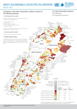
Infographic on most vulnerable localities (as of March 2015)
Most Vulnerable Localities in Lebanon - March 2015 (Map or infographic, English)
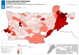
Akkar Governorate: Situation map on displacement (distribution of registered Syrian refugees) (as of 28 February 2015)
Syria Refugee Response; Lebanon, Akkar Governorate; Distribution of the Registered Syrian Refugees at the Cadastral Level; As of 28 February 2015 (Map or infographic, English)
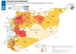
Situation map on places of origin of Syrian refugees registered in Lebanon (as of 28 February 2015)
Syria Refugee Response; Lebanon: Places of Origin of Syrian Refugees Registered in Lebanon; 28 February 2015 (Map or infographic, English)
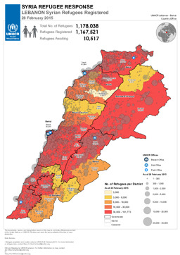
Situation map on displacement (distribution of registered Syrian refugees in Lebanon) (as of 28 February 2015)
Syria Refugee Response; Lebanon; Syrian Refugees Registered; 28 February 2015 (Map or infographic, English)
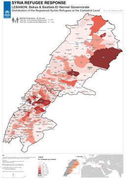
Situation map on displacement (distribution of registered Syrian refugees in Bekaa and Baalbek-El Hermel Governorates) (as of 28 February 2014)
Syria Refugee Response; Lebanon, Bekaa & Baalbek- El Hermel Governorate; Distribution of the Registered Syrian Refugees at the Cadastral Level; As of 28 February 2014 (Map or infographic, English)
Documents found: 244
