Maps
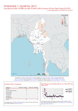
Update on conflict-related incidents according to the Armed Conflict Location & Event Data Project (covering first quarter 2017)
Myanmar, 1. Quartal 2017: Kurzübersicht über Vorfälle aus dem Armed Conflict Location & Event Data Project (ACLED) (Map or infographic, German)
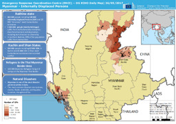
Situation map on internal displacement as of May 2017
Myanmar - Internally Displaced Persons – DG ECHO Daily Map | 26/05/2017 (Map or infographic, English)
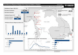
Situation map on the resettlement of Myanmar refugees from temporary shelters in Thailand
Resettlement of Myanmar Refugees from Temporary Shelters in Thailand; 28 February 2017 (Map or infographic, English)
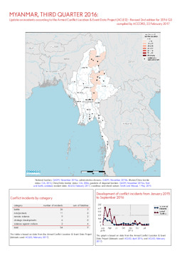
Update on incidents according to the Armed Conflict Location & Event Data Project (covering 3rd quarter 2016) (revised edition)
Myanmar, 3. Quartal 2016: Kurzübersicht über Vorfälle aus dem Armed Conflict Location & Event Data Project (ACLED) - Korrigierte 2. Version für 2016 Q3 (Map or infographic, English)
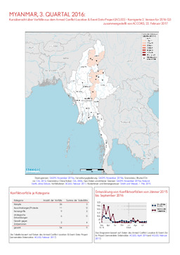
Update on incidents according to the Armed Conflict Location & Event Data Project (covering 3rd quarter 2016) (revised edition)
Myanmar, 3. Quartal 2016: Kurzübersicht über Vorfälle aus dem Armed Conflict Location & Event Data Project (ACLED) - Korrigierte 2. Version für 2016 Q3 (Map or infographic, German)
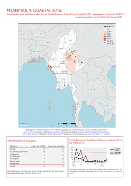
Update on conflict-related incidents according to the Armed Conflict Location & Event Data Project (covering first quarter 2016) (revised edition)
Myanmar, 1. Quartal 2016: Kurzübersicht über Vorfälle aus dem Armed Conflict Location & Event Data Project (ACLED) - Korrigierte 2. Version für 2016 Q1 (Map or infographic, English)
Update on conflict-related incidents according to the Armed Conflict Location & Event Data Project (covering 2nd quarter 2016) (revised edition)
Myanmar, 2. Quartal 2016: Kurzübersicht über Vorfälle aus dem Armed Conflict Location & Event Data Project (ACLED) - Korrigierte 2. Version für 2016 Q2 (Map or infographic, German)
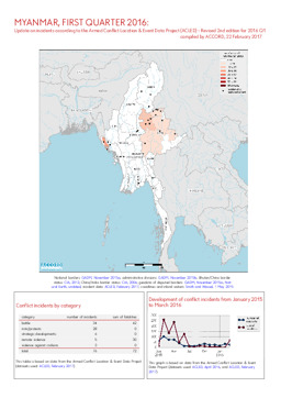
Update on conflict-related incidents according to the Armed Conflict Location & Event Data Project (covering first quarter 2016) (revised edition)
Myanmar, 1. Quartal 2016: Kurzübersicht über Vorfälle aus dem Armed Conflict Location & Event Data Project (ACLED) - Korrigierte 2. Version für 2016 Q1 (Map or infographic, German)
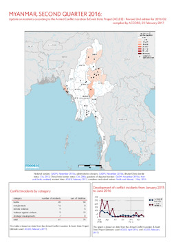
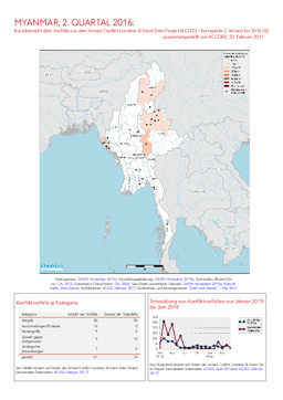
Update on conflict-related incidents according to the Armed Conflict Location & Event Data Project (covering 2nd quarter 2016) (revised edition)
Myanmar, 2. Quartal 2016: Kurzübersicht über Vorfälle aus dem Armed Conflict Location & Event Data Project (ACLED) - Korrigierte 2. Version für 2016 Q2 (Map or infographic, English)
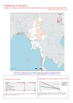
Update on incidents according to the Armed Conflict Location & Event Data Project (covering 2016)
Myanmar, Jahr 2016: Kurzübersicht über Vorfälle aus dem Armed Conflict Location & Event Data Project (ACLED) (Map or infographic, English)
Documents found: 495
