Maps
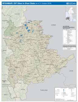
Shan state: Situation map on internally displaced persons (IDPs) camps (as of 31 October 2018)
Myanmar: IDP Sites in Shan State (31 October 2018) (Map or infographic, English)
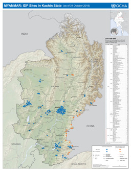
Kachin state: Situation map on internally displaced persons (IDPs) camps (as of 31 October 2018)
Myanmar: IDP Sites in Kachin State (31 October 2018) (Map or infographic, English)
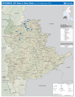
Shan state: Situation map on internally displaced persons (IDPs) camps (as of 30 September 2018)
Myanmar: IDP Sites in Shan State (30 September 2018) (Map or infographic, English)

Kachin state: Situation map on internally displaced persons (IDPs) camps (as of 30 September 2018)
Myanmar: IDP Sites in Kachin State (30 September 2018) (Map or infographic, English)
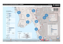
Situation map on voluntary repatriation
Facilitated Voluntary Repatriation - Summary; 8 June 2018 (Map or infographic, English)
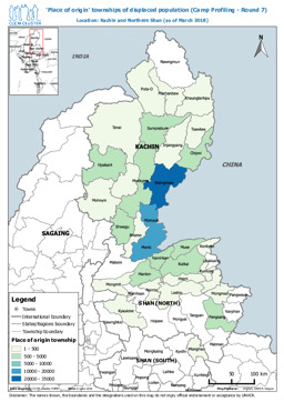
Situation map on places of origin of the displaced population
'Place of origin' townships of displaced population (Camp Profiling - Round 7); Location: Kachin and Northern Shan (as of March 2018) (Map or infographic, English)
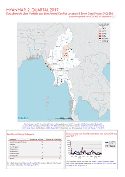
Update on conflict-related incidents according to the Armed Conflict Location & Event Data Project (covering second quarter 2017)
Myanmar, 2. Quartal 2017: Kurzübersicht über Vorfälle aus dem Armed Conflict Location & Event Data Project (ACLED) (Map or infographic, German)
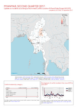
Update on conflict-related incidents according to the Armed Conflict Location & Event Data Project (covering second quarter 2017)
Myanmar, 2. Quartal 2017: Kurzübersicht über Vorfälle aus dem Armed Conflict Location & Event Data Project (ACLED) (Map or infographic, English)
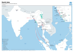
Situation map on the movement of Rohingya refugees from Myanmar in the South Asia region (as of 4 September 2017)
South Asia; Rohingya Refugee movements from Myanmar; as of 04 Sep 2017 (Map or infographic, English)
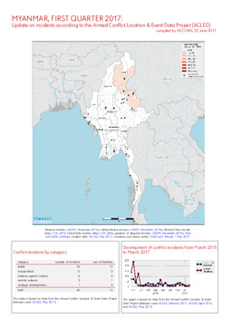
Update on conflict-related incidents according to the Armed Conflict Location & Event Data Project (covering first quarter 2017)
Myanmar, 1. Quartal 2017: Kurzübersicht über Vorfälle aus dem Armed Conflict Location & Event Data Project (ACLED) (Map or infographic, English)
Documents found: 495
