Maps
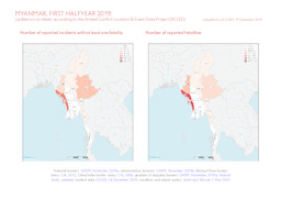
Update on conflict-related incidents according to the Armed Conflict Location & Event Data Project (covering first halfyear 2019)
Myanmar, first halfyear 2019: Update on incidents according to the Armed Conflict Location & Event Data Project (ACLED) (Map or infographic, English)
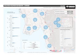
Map on voluntary repatriation
Facilitated Voluntary Repatriation - Summary; 11 July 2019 (Map or infographic, English)
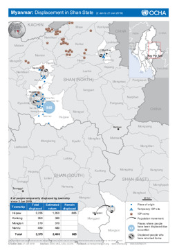
Shan state: Situation map on displacement (covering 2 - 21 January 2019)
Myanmar: Displacement in Shan State (2 Jan to 21 Jan 2019) (Map or infographic, English)
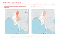
Update on conflict-related incidents according to the Armed Conflict Location & Event Data Project (covering first quarter 2018)
Myanmar, 1. Quartal 2018: Kurzübersicht über Vorfälle aus dem Armed Conflict Location & Event Data Project (ACLED) - aktualisierte 2. Version (Map or infographic, German)
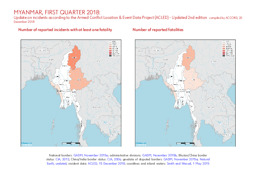
Update on conflict-related incidents according to the Armed Conflict Location & Event Data Project (covering first quarter 2018)
Myanmar, first quarter 2018: Update on incidents according to the Armed Conflict Location & Event Data Project (ACLED) - Updated 2nd edition (Map or infographic, English)
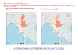
Update on conflict-related incidents according to the Armed Conflict Location & Event Data Project (covering second quarter 2018)
Myanmar, 2. Quartal 2018: Kurzübersicht über Vorfälle aus dem Armed Conflict Location & Event Data Project (ACLED) - aktualisierte 2. Version (Map or infographic, German)
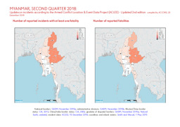
Update on conflict-related incidents according to the Armed Conflict Location & Event Data Project (covering second quarter 2018)
Myanmar, second quarter 2018: Update on incidents according to the Armed Conflict Location & Event Data Project (ACLED) - Updated 2nd edition (Map or infographic, English)
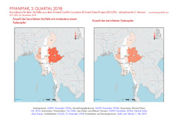
Update on conflict-related incidents according to the Armed Conflict Location & Event Data Project (covering third quarter 2018)
Myanmar, 3. Quartal 2018: Kurzübersicht über Vorfälle aus dem Armed Conflict Location & Event Data Project (ACLED) - aktualisierte 2. Version (Map or infographic, German)
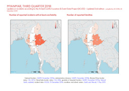
Update on conflict-related incidents according to the Armed Conflict Location & Event Data Project (covering third quarter 2018)
Myanmar, third quarter 2018: Update on incidents according to the Armed Conflict Location & Event Data Project (ACLED) - Updated 2nd edition (Map or infographic, English)
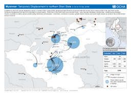
Shan state: Situation map on temporary displacement (covering 1 October - 10 December 2018)
Myanmar: Temporary Displacement in northern Shan State (1 Oct to 10 Dec 2018) (Map or infographic, English)
Documents found: 495
