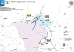
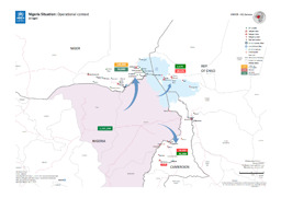
29 September 2015 | UNHCR – UN High Commissioner for Refugees (Author)
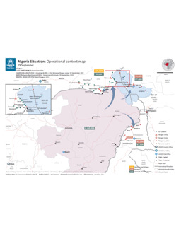
Cameroon, Chad, Niger, Nigeria
Situation map on displacement (distribution of IDPS; distribution of Nigerian refugees in neighbouring countries) (as of 29 September 2015)
Nigeria Situation: Operational context map (Map or infographic, English)
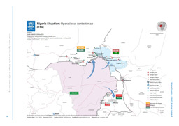
4 September 2015 | UNHCR – UN High Commissioner for Refugees (Author)
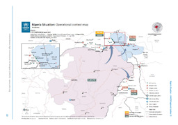
Cameroon, Chad, Niger, Nigeria
Situation map on displacement (distribution of IDPS; distribution of Nigerian refugees in neighbouring countries) (as of 4 September 2015)
Nigeria Situation: Operational context map (Map or infographic, English)
August 2015 | BFA Staatendokumentation (Austrian Federal Office for Immigration and Asylum, COI unit) (Author)
Afghanistan, Albania, Algeria, Angola, Argentina, Armenia, Australia, Austria, Azerbaijan, Bahrain, Bangladesh, Belarus, Belgium, Benin, Bhutan, Bolivia, Bosnia and Herzegovina, Botswana, Brazil, Bulgaria, Burkina Faso, Burundi, Cambodia, Cameroon, Canada, Central African Republic, Chad, Chile, China, Colombia, Congo, Congo, Democratic Republic, Costa Rica, Croatia, Cuba, Cyprus, Czech Republic, Côte d'Ivoire, Denmark, Djibouti, Dominican Republic, Ecuador, Egypt, El Salvador, Equatorial Guinea, Eritrea, Estonia, Eswatini, Ethiopia, Finland, France, Gabon, Gambia, Georgia, Germany, Ghana, Greece, Guatemala, Guinea, Guinea-Bissau, Haiti, Honduras, Hungary, Iceland, India, Indonesia, Iran, Iraq, Ireland, Israel, Italy, Jamaica, Japan, Jordan, Kazakhstan, Kenya, Korea, Democratic People's Republic, Korea, Republic, Kosovo, Kuwait, Kyrgyzstan, Lao People's Democratic Republic, Latvia, Lebanon, Lesotho, Liberia, Libya, Liechtenstein, Lithuania, Luxembourg, Madagascar, Malawi, Malaysia, Maldives, Mali, Malta, Mauritania, Mexico, Moldova, Republic, Mongolia, Montenegro, Morocco, Mozambique, Myanmar, Namibia, Nepal, Netherlands, New Zealand, Nicaragua, Niger, Nigeria, North Macedonia, Norway, Oman, Pakistan, Panama, Paraguay, Peru, Philippines, Poland, Portugal, Qatar, Romania, Russian Federation, Rwanda, Saudi Arabia, Senegal, Serbia, Sierra Leone, Singapore, Slovakia, Slovenia, Somalia, South Africa, South Sudan, Spain, Sri Lanka, State of Palestine, Sudan, Suriname, Sweden, Switzerland, Syrian Arab Republic, Taiwan, Tajikistan, Tanzania, United Republic, Thailand, Timor-Leste, Togo, Tunisia, Turkmenistan, Türkiye, Uganda, Ukraine, United Arab Emirates, United Kingdom, United States of America, Uruguay, Uzbekistan, Venezuela, Vietnam, Western Sahara, Yemen, Zambia, Zimbabwe
Infographics: Thematic atlas on demography and migration, globally and in Europe (population density; population age; migration; displacement)
Atlas Demographie & Migration 2015 (Map or infographic, German)
August 2015 | BFA Staatendokumentation (Austrian Federal Office for Immigration and Asylum, COI unit) (Author)
Afghanistan, Albania, Algeria, Angola, Argentina, Armenia, Australia, Austria, Azerbaijan, Bahrain, Bangladesh, Belarus, Belgium, Benin, Bhutan, Bolivia, Bosnia and Herzegovina, Botswana, Brazil, Bulgaria, Burkina Faso, Burundi, Cambodia, Cameroon, Canada, Central African Republic, Chad, Chile, China, Colombia, Congo, Congo, Democratic Republic, Costa Rica, Croatia, Cuba, Cyprus, Czech Republic, Côte d'Ivoire, Denmark, Djibouti, Dominican Republic, Ecuador, Egypt, El Salvador, Equatorial Guinea, Eritrea, Estonia, Eswatini, Ethiopia, Finland, France, Gabon, Gambia, Georgia, Germany, Ghana, Greece, Guatemala, Guinea, Guinea-Bissau, Haiti, Honduras, Hungary, Iceland, India, Indonesia, Iran, Iraq, Ireland, Israel, Italy, Jamaica, Japan, Jordan, Kazakhstan, Kenya, Korea, Democratic People's Republic, Korea, Republic, Kosovo, Kuwait, Kyrgyzstan, Lao People's Democratic Republic, Latvia, Lebanon, Lesotho, Liberia, Libya, Liechtenstein, Lithuania, Luxembourg, Madagascar, Malawi, Malaysia, Maldives, Mali, Malta, Mauritania, Mexico, Moldova, Republic, Mongolia, Montenegro, Morocco, Mozambique, Myanmar, Namibia, Nepal, Netherlands, New Zealand, Nicaragua, Niger, Nigeria, North Macedonia, Norway, Oman, Pakistan, Panama, Paraguay, Peru, Philippines, Poland, Portugal, Qatar, Romania, Russian Federation, Rwanda, Saudi Arabia, Senegal, Serbia, Sierra Leone, Singapore, Slovakia, Slovenia, Somalia, South Africa, South Sudan, Spain, Sri Lanka, State of Palestine, Sudan, Suriname, Sweden, Switzerland, Syrian Arab Republic, Taiwan, Tajikistan, Tanzania, United Republic, Thailand, Timor-Leste, Togo, Tunisia, Turkmenistan, Türkiye, Uganda, Ukraine, United Arab Emirates, United Kingdom, United States of America, Uruguay, Uzbekistan, Venezuela, Vietnam, Western Sahara, Yemen, Zambia, Zimbabwe
Infographics: Thematic atlas on demography and migration, globally and in Europe (population density; population age; migration; displacement)
Atlas Demography & Migration 2015 (Map or infographic, English)
25 June 2015 | UNHCR – UN High Commissioner for Refugees (Author)
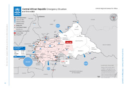
Cameroon, Central African Republic, Chad, Congo, Congo, Democratic Republic
Situation map on refugees as well as internally displaced people and UNHCR units in and around the Central Africain Republic (as of 25 June 2015)
Central African Republic Emergency Sitaution; as of 25 June 2015 (Map or infographic, English)
29 May 2015 | UNHCR – UN High Commissioner for Refugees (Author)
Cameroon, Chad, Nigeria
Situation map on displacement (distribution of IDPS; distribution of Nigerian refugees in neighbouring countries) (as of 29 May 2015)
Nigeria Situation: Operational context map (Map or infographic, English)
28 May 2015 | UNHCR – UN High Commissioner for Refugees (Author)
Cameroon, Chad, Niger
Situation map on the displacement of Nigerians into neighbouring countries (as of 28 May 2015)
Nigeria Situation: Operational context map; 28 May (Map or infographic, English)
8 May 2015 | UNHCR – UN High Commissioner for Refugees (Author)
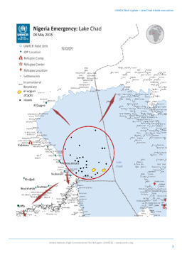
Chad, Niger, Nigeria
Situation map on refugee movements, settlements and principal attacks at Lake Chad (as of 8 May 2015)
Nigeria Emergency: Lake Chad (Map or infographic, English)
May 2015 | UNHCR – UN High Commissioner for Refugees (Author)
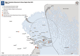
Chad, Niger
Situation map on the population movement in the Bosso Region (as of May 2015)
Niger: Population Movement in Bosso Region May 2015 (Map or infographic, English)
10 April 2015 | UNHCR – UN High Commissioner for Refugees (Author)
Cameroon, Chad, Niger
Situation map on the situation in Nigeria in an operational context (as of 10 April 2015)
Nigeria Situation: Operational context; 10 April (Map or infographic, English)
