Maps
Situation map on the distribution of refugees from South Sudan, with administrative divisions (state level) (covering 15 December 2013 to 29 August 2014)
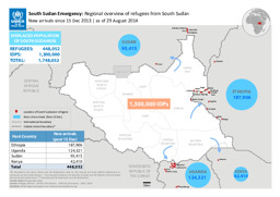
South Sudan Emergency: Regional overview of refugees from South Sudan; New arrivals since 15 Dec 2013 as of 29 August 2014 (Map or infographic, English)
Situation map on the distribution of refugees from South Sudan, with administrative divisons (state level) (as of 24 July 2014)
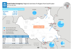
South Sudan Emergency: Regional overview of refugees from South Sudan; As of 24 July 2014 (Map or infographic, English)
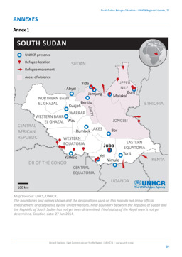
Situation map on UNHCR presence, areas of violence, refugee locations and refugee movements
South Sudan Refugee Situation - UNHCR Regional Update, 22 (Map or infographic, English)
Sitation map on the distribution of refugees from South Sudan, with administrative divisions (state level) (as of 30 May 2014)
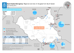
South Sudan Emergency: Regional overview of refugees from South Sudan; As of 30 May 2014 (Map or infographic, English)
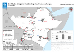
Situation map of camps and settlements of South Sudanese refugees in South Sudan, Ethiopia, Kenya and Uganda (as of 14 January 2014)
South Sudan Emergency Situation Map: South Sudanese Refugees; 14 January 2014 (Map or infographic, English)
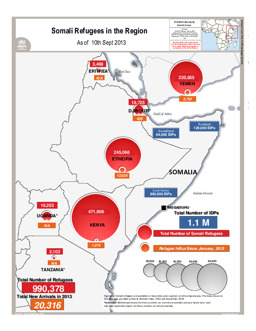
Situation map on the distribution of Somali refugees in the region (as of 10 September 2013)
Somali Refugees in the Region; As of 10th September 2013 (Map or infographic, English)
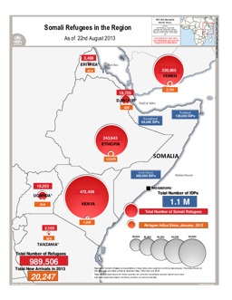
Situation map on the distribution of Somali refugees in the region (as of 22 August 2013)
Somali Refugees in the Region; As of 22nd August 2013 (Map or infographic, English)
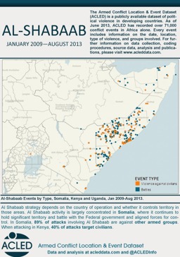
Situation map on conflict events involving Al-Shabaab (covering 2009-2013) (see also ID 315005)
Al-Shabaab Activity Mapped (August 2013) (Map or infographic, English)
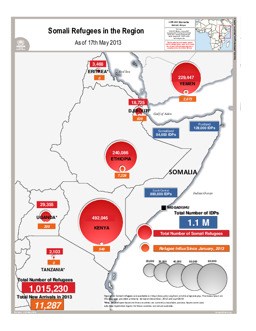
Situation map on the distribution of Somali refugees in the region (as of 17 May 2013)
Somali Refugees in the Region; As of 17th May 2013 (Map or infographic, English)
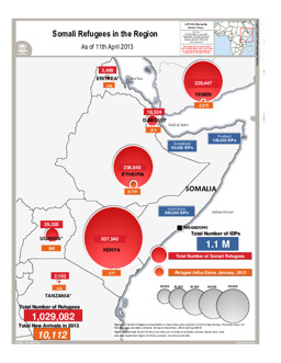
Situation map on the distribution of Somali refugees in the region (as of 11 April 2013)
Somali Refugees in the Region; As of 11th April 2013 (Map or infographic, English)
Documents found: 230
