Maps
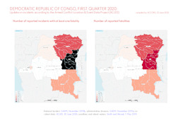
Update on conflict-related incidents according to the Armed Conflict Location & Event Data Project (covering first quarter of 2020)
Democratic Republic of Congo, first quarter 2020: Update on incidents according to the Armed Conflict Location & Event Data Project (ACLED) (Map or infographic, English)
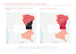
Update on conflict-related incidents according to the Armed Conflict Location & Event Data Project (covering first quarter of 2020)
Demokratische Republik Kongo, 1. Quartal 2020: Kurzübersicht über Vorfälle aus dem Armed Conflict Location & Event Data Project (ACLED) (Map or infographic, German)
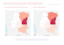
Update on conflict-related incidents according to the Armed Conflict Location & Event Data Project (covering fourth quarter of 2019)
Democratic Republic of Congo, fourth quarter 2019: Update on incidents according to the Armed Conflict Location & Event Data Project (ACLED) (Map or infographic, English)
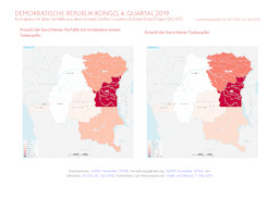
Update on conflict-related incidents according to the Armed Conflict Location & Event Data Project (covering fourth quarter of 2019)
Demokratische Republik Kongo, 4. Quartal 2019: Kurzübersicht über Vorfälle aus dem Armed Conflict Location & Event Data Project (ACLED) (Map or infographic, German)
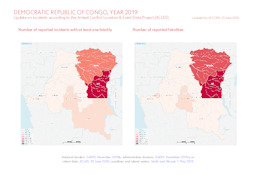
Update on conflict-related incidents according to the Armed Conflict Location & Event Data Project (covering 2019)
Democratic Republic of Congo, year 2019: Update on incidents according to the Armed Conflict Location & Event Data Project (ACLED) (Map or infographic, English)
Update on conflict-related incidents according to the Armed Conflict Location & Event Data Project (covering 2019)
Demokratische Republik Kongo, Jahr 2019: Kurzübersicht über Vorfälle aus dem Armed Conflict Location & Event Data Project (ACLED) (Map or infographic, German)

Équateur province: Infographic on the distribution of languages
Language map of Équateur province; Democratic Republic of Congo (Map or infographic, English)
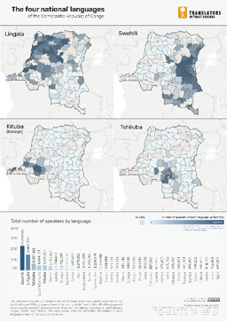
Infographic on the distribution of the 4 national languages of the Democratic Republic of the Congo (Lingala, Swahili, Kituba and Tshiluba)
The four national languages of the Democratic Republic of Congo (Map or infographic, English)
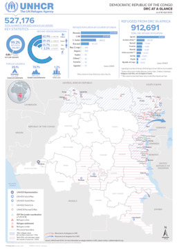
Situation map on the distribution of IDP and refugee sites as well as UNHCR offices (as of 30 April 2020)
Democratic Republic of the Congo; DRC at a glance; as of 30 April 2020 (Map or infographic, English)
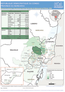
North Kivu province: Situation map on displacement
Republique Democratique du Congo; Province du Nord-Kivu; Zones de provenance des personnes vivant dans les sites de déplacement au 25 février 2019 (Map or infographic, French)
Documents found: 552
