Maps
Update on conflict-related incidents according to the Armed Conflict Location & Event Data Project (covering 4th quarter 2024)
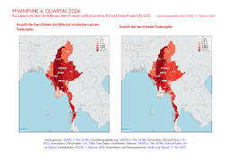
Myanmar, 4. Quartal 2024: Kurzübersicht über Vorfälle aus dem Armed Conflict Location & Event Data Project (ACLED) (Map or infographic, German)

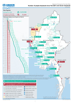
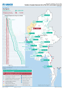
Situation maps with administrative divisions (province level) on displacement (distribution of IDPs; distribution of refugees) (as of 10 February 2025)
Myanmar Emergency Overview Map; Number of people displaced since Feb 2021 and remain displaced as of 10 Feb 2025 (Map or infographic, English)
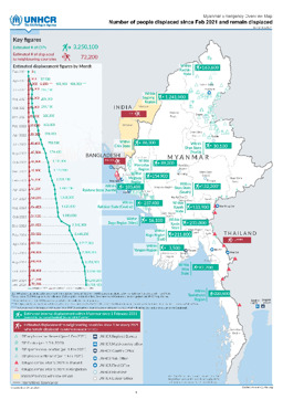
Situation maps with administrative divisions (province level) on displacement (distribution of IDPs; distribution of refugees) (as of 27 January 2025)
Myanmar Emergency Overview Map; Number of people displaced since Feb 2021 and remain displaced (as of 27 Jan 2025) (Map or infographic, English)
Situation maps with administrative divisions (province level) on displacement (distribution of IDPs; distribution of refugees) (as of 20 January 2025)
Myanmar Emergency Overview Map; Number of people displaced since Feb 2021 and remain displaced (as of 20 Jan 2025) (Map or infographic, English)

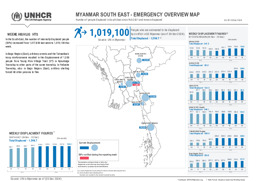
South-East Myanmar: Infographic with administrative divisions (province level) and main cities on the distribution of IDPs (as of 13 January 2025)
Myanmar South East - Emergency Overview Map; Number of people displaced in South East since 2021 and remain displaced; As of 13 Jan 2025 (Map or infographic, English)
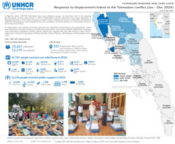
Infographic on displacement linked to conflict between the Arakan Army and the Tatmadaw in Rakhine and Chin states (covering January to December 2024)
Myanmar/Rakhine and Chin State; Response to displacement linked to AA-Tatmadaw conflict (Jan - Dec 2024) as of 31 Dec 2024 (Map or infographic, English)

Situation maps with administrative divisions (province level) on displacement (distribution of IDPs; distribution of refugees) (as of 30 December 2024)
Myanmar Emergency Overview Map; Number of people displaced since Feb 2021 and remain displaced (as of 30 Dec 2024) (Map or infographic, English)
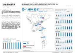
South-East Myanmar: Infographic with administrative divisions (province level) and main cities on the distribution of IDPs (as of 30 December 2024)
Myanmar South East - Emergency Overview Map; Number of people displaced in South East since Feb 2021 and remain displaced; As of 30 Dec 2024 (Map or infographic, English)
South-East Myanmar: Infographic with administrative divisions (province level) and main cities on the distribution of IDPs (as of 16 December 2024)
Myanmar South East - Emergency Overview Map; Number of people displaced in South East since Feb 2021 and remain displaced; As of 16 Dec 2024 (Map or infographic, English)
Situation maps with administrative divisions (province level) on displacement (distribution of IDPs; distribution of refugees) (as of 16 December 2024)
Myanmar Emergency Overview Map; Number of people displaced since Feb 2021 and remain displaced (as of 16 Dec 2024) (Map or infographic, English)
Documents found: 495
