Maps

Situation maps with administrative divisions (province level) on displacement (distribution of IDPs; distribution of refugees) (as of 17 March 2025)
Myanmar Emergency Overview Map; Number of people displaced since Feb 2021 and remain displaced as of 17 March 2025 (Map or infographic, English)
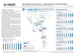
South-East Myanmar: Infographic on the distribution of IDPs (as of 10 March 2025)
Myanmar South East - Emergency Overview Map; Number of people displaced in South East since Feb 2021 and remain displaced; As of 10 Mar 2025 (Map or infographic, English)

Situation maps with administrative divisions (province level) on displacement (distribution of IDPs; distribution of refugees) (as of 10 March 2025)
Myanmar Emergency Overview Map; Number of people displaced since Feb 2021 and remain displaced as of 10 March 2025 (Map or infographic, English)
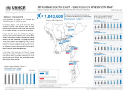
South-East Myanmar: Infographic on the distribution of IDPs (as of 3 March 2024)
Myanmar South East - Emergency Overview Map; Number of people displaced in South East since Feb 2021 and remain displaced; As of 03 Mar 2025 (Map or infographic, English)

Situation maps with administrative divisions (province level) on displacement (distribution of IDPs; distribution of refugees) (as of 3 March 2025)
Myanmar Emergency Overview Map; Number of people displaced since Feb 2021 and remain displaced as of 03 March 2025 (Map or infographic, English)
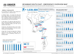
South-East Myanmar: Infographic on the distribution of IDPs (as of 24 February 2025)
Myanmar South East - Emergency Overview Map; Number of people displaced in South East since Feb 2021 and remain displaced; As of 24 Feb 2025 (Map or infographic, English)

Situation maps with administrative divisions (province level) on displacement (distribution of IDPs; distribution of refugees) (as of 24 February 2025)
Myanmar Emergency Overview Map; Number of people displaced since Feb 2021 and remain displaced as of 24 Feb 2025 (Map or infographic, English)
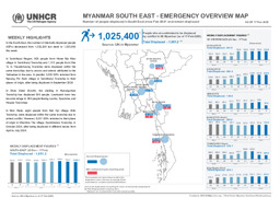
South-East Myanmar: Infographic with administrative divisions (province level) and main cities on the distribution of IDPs (as of 17 February 2025)
Myanmar South East - Emergency Overview Map; Number of people displaced in South East since Feb 2021 and remain displaced; As of 17 Feb 2025 (Map or infographic, English)

Situation maps with administrative divisions (province level) on displacement (distribution of IDPs; distribution of refugees) (as of 17 February 2025)
Myanmar Emergency Overview Map; Number of people displaced since Feb 2021 and remain displaced as of 17 Feb 2025 (Map or infographic, English)
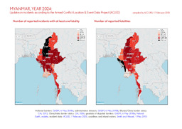
Update on conflict-related incidents according to the Armed Conflict Location & Event Data Project (covering 2024)
Myanmar, year 2024: Update on incidents according to the Armed Conflict Location & Event Data Project (ACLED) (Map or infographic, English)
Documents found: 499
