Maps
Situation map on displacement since February 2021
Myanmar Emergency Overview Map; Number of people displaced since Feb 2021 and remain displaced (Map or infographic, English)
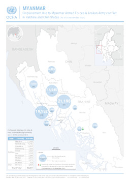
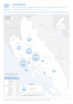
Situation map on displacement due to conflict between Myanmar armed forces and Arakan army (as of 30 November 2021)
Myanmar: Displacement due to Myanmar Armed Forces & Arakan Army conflict in Rakhine and Chin States (As of 30 November 2021) (Map or infographic, English)
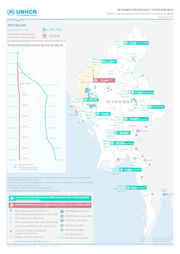
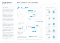
Situation map on displacement since February 2021
Myanmar Emergency Overview Map; Number of people displaced since Feb 2021 and remain displaced (as of 29 November 2021) (Map or infographic, English)
Situation map on displacement since February 2021
Myanmar Emergency Overview Map; Number of people displaced in South East since Feb 2021 and remain displaced; As of 29 Nov 2021 (Map or infographic, English)

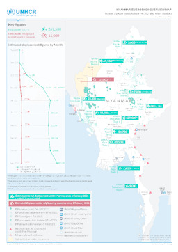
Situation map on displacement since February 2021
Myanmar Emergency Overview Map; Number of people displaced since Feb 2021 and remain displaced (as of 22 November 2021) (Map or infographic, English)
South-East Myanmar: Situation map on displacement since February 2021
Myanmar Emergency Overview Map; Number of people displaced in South East since Feb 2021 and remain displaced; As of 22 Nov 2021 (Map or infographic, English)
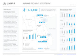
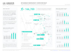
Situation map on displacement since February 2021
Myanmar Emergency Overview Map; Number of people displaced since Feb 2021 and remain displaced (as of 15 November 2021) (Map or infographic, English)
South-East Myanmar: Situation map on displacement since February 2021
Myanmar Emergency Overview Map; Number of people displaced in South East since Feb 2021 and remain displaced; As of 15 Nov 2021 (Map or infographic, English)
Situation map on displacement due to conflict between Myanmar armed forces and Arakan army (as of 15 November 2021)
Myanmar: Displacement due to Myanmar Armed Forces & Arakan Army conflict in Rakhine and Chin States (As of 15 November 2021) (Map or infographic, English)
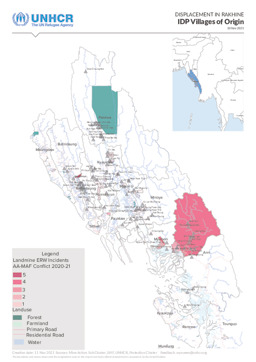
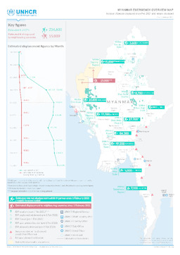
Situation map on displacement (villages of origin of IDPs)
Displacement in Rakhine; IDP Villages of Origin; 10 Nov 2021 (Map or infographic, English)
Documents found: 495
