30 November 2021 | UNHCR – UN High Commissioner for Refugees (Author)
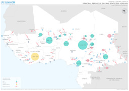
Benin, Burkina Faso, Cameroon, Central African Republic, Chad, Congo, Congo, Democratic Republic, Côte d'Ivoire, Ghana, Guinea, Guinea-Bissau, Liberia, Mali, Mauritania, Niger, Nigeria, Senegal, Sierra Leone, South Sudan, Togo
West and Central Africa: Situation map on displacement (distribution of refugees; distribution of IDPs; distribution of stateless persons) (as of 30 November 2021)
West & Central Africa; Principal Refugees, IDPs and Stateless Persons (Map or infographic, English)
7 December 2020 | UNHCR – UN High Commissioner for Refugees (Author)
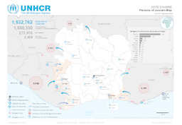
Côte d'Ivoire, Ghana, Liberia, Mali, Togo
Situation map on the distribution of stateless persons or those at risk of statelessness, returnees, refugees and asylum-seekers (as of 7 December 2020)
Côte d’Ivoire; Persons of concern Map; As of 07 Decembre 2020 (Map or infographic, English)
12 September 2019 | UNHCR – UN High Commissioner for Refugees (Author)
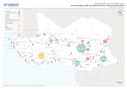
Benin, Burkina Faso, Cameroon, Central African Republic, Chad, Côte d'Ivoire, Gambia, Ghana, Guinea, Guinea-Bissau, Liberia, Mali, Mauritania, Niger, Nigeria, Senegal, Sierra Leone, Sudan, Togo
West and Central Africa: Situation map on displacement (distribution of refugees; distribution of IDPs; distribution of stateless persons) (as of 12 September 2019)
Regional Bureau for West & Central Africa; Principal Refugees, IDPs and Stateless Persons in West and Central Africa; Statistics available as of 12 September, 2019 (Map or infographic, English)
2016 | CIA – Central Intelligence Agency (Author), published by University of Texas Libraries
Liberia
Small map of Liberia
Liberia (Small Map) 2016 (Map or infographic, English)
August 2015 | BFA Staatendokumentation (Austrian Federal Office for Immigration and Asylum, COI unit) (Author)
Afghanistan, Albania, Algeria, Angola, Argentina, Armenia, Australia, Austria, Azerbaijan, Bahrain, Bangladesh, Belarus, Belgium, Benin, Bhutan, Bolivia, Bosnia and Herzegovina, Botswana, Brazil, Bulgaria, Burkina Faso, Burundi, Cambodia, Cameroon, Canada, Central African Republic, Chad, Chile, China, Colombia, Congo, Congo, Democratic Republic, Costa Rica, Croatia, Cuba, Cyprus, Czech Republic, Côte d'Ivoire, Denmark, Djibouti, Dominican Republic, Ecuador, Egypt, El Salvador, Equatorial Guinea, Eritrea, Estonia, Eswatini, Ethiopia, Finland, France, Gabon, Gambia, Georgia, Germany, Ghana, Greece, Guatemala, Guinea, Guinea-Bissau, Haiti, Honduras, Hungary, Iceland, India, Indonesia, Iran, Iraq, Ireland, Israel, Italy, Jamaica, Japan, Jordan, Kazakhstan, Kenya, Korea, Democratic People's Republic, Korea, Republic, Kosovo, Kuwait, Kyrgyzstan, Lao People's Democratic Republic, Latvia, Lebanon, Lesotho, Liberia, Libya, Liechtenstein, Lithuania, Luxembourg, Madagascar, Malawi, Malaysia, Maldives, Mali, Malta, Mauritania, Mexico, Moldova, Republic, Mongolia, Montenegro, Morocco, Mozambique, Myanmar, Namibia, Nepal, Netherlands, New Zealand, Nicaragua, Niger, Nigeria, North Macedonia, Norway, Oman, Pakistan, Panama, Paraguay, Peru, Philippines, Poland, Portugal, Qatar, Romania, Russian Federation, Rwanda, Saudi Arabia, Senegal, Serbia, Sierra Leone, Singapore, Slovakia, Slovenia, Somalia, South Africa, South Sudan, Spain, Sri Lanka, State of Palestine, Sudan, Suriname, Sweden, Switzerland, Syrian Arab Republic, Taiwan, Tajikistan, Tanzania, United Republic, Thailand, Timor-Leste, Togo, Tunisia, Turkmenistan, Türkiye, Uganda, Ukraine, United Arab Emirates, United Kingdom, United States of America, Uruguay, Uzbekistan, Venezuela, Vietnam, Western Sahara, Yemen, Zambia, Zimbabwe
Infographics: Thematic atlas on demography and migration, globally and in Europe (population density; population age; migration; displacement)
Atlas Demographie & Migration 2015 (Map or infographic, German)
August 2015 | BFA Staatendokumentation (Austrian Federal Office for Immigration and Asylum, COI unit) (Author)
Afghanistan, Albania, Algeria, Angola, Argentina, Armenia, Australia, Austria, Azerbaijan, Bahrain, Bangladesh, Belarus, Belgium, Benin, Bhutan, Bolivia, Bosnia and Herzegovina, Botswana, Brazil, Bulgaria, Burkina Faso, Burundi, Cambodia, Cameroon, Canada, Central African Republic, Chad, Chile, China, Colombia, Congo, Congo, Democratic Republic, Costa Rica, Croatia, Cuba, Cyprus, Czech Republic, Côte d'Ivoire, Denmark, Djibouti, Dominican Republic, Ecuador, Egypt, El Salvador, Equatorial Guinea, Eritrea, Estonia, Eswatini, Ethiopia, Finland, France, Gabon, Gambia, Georgia, Germany, Ghana, Greece, Guatemala, Guinea, Guinea-Bissau, Haiti, Honduras, Hungary, Iceland, India, Indonesia, Iran, Iraq, Ireland, Israel, Italy, Jamaica, Japan, Jordan, Kazakhstan, Kenya, Korea, Democratic People's Republic, Korea, Republic, Kosovo, Kuwait, Kyrgyzstan, Lao People's Democratic Republic, Latvia, Lebanon, Lesotho, Liberia, Libya, Liechtenstein, Lithuania, Luxembourg, Madagascar, Malawi, Malaysia, Maldives, Mali, Malta, Mauritania, Mexico, Moldova, Republic, Mongolia, Montenegro, Morocco, Mozambique, Myanmar, Namibia, Nepal, Netherlands, New Zealand, Nicaragua, Niger, Nigeria, North Macedonia, Norway, Oman, Pakistan, Panama, Paraguay, Peru, Philippines, Poland, Portugal, Qatar, Romania, Russian Federation, Rwanda, Saudi Arabia, Senegal, Serbia, Sierra Leone, Singapore, Slovakia, Slovenia, Somalia, South Africa, South Sudan, Spain, Sri Lanka, State of Palestine, Sudan, Suriname, Sweden, Switzerland, Syrian Arab Republic, Taiwan, Tajikistan, Tanzania, United Republic, Thailand, Timor-Leste, Togo, Tunisia, Turkmenistan, Türkiye, Uganda, Ukraine, United Arab Emirates, United Kingdom, United States of America, Uruguay, Uzbekistan, Venezuela, Vietnam, Western Sahara, Yemen, Zambia, Zimbabwe
Infographics: Thematic atlas on demography and migration, globally and in Europe (population density; population age; migration; displacement)
Atlas Demography & Migration 2015 (Map or infographic, English)
September 2014 | UN Cartographic Section (Author)
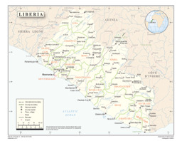
Liberia
Map of Liberia
Liberia (Map or infographic, English)
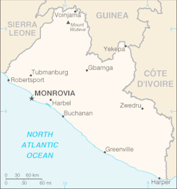
2013 | U.S. Central Intelligence Agency (Author), published by University of Texas Libraries

Liberia
Small map
Liberia (Small Map) 2013 (Map or infographic, English)
22 February 2011 | UNHCR – UN High Commissioner for Refugees (Author)
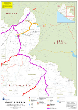
Liberia
Map of East Liberia: Refugees sites and road conditions
East Liberia - Refugees Sites and Road Conditions (as of 18 Feb 2011) (Map or infographic, English)
7 January 2011 | EQUIP Liberia (Author), published by ReliefWeb
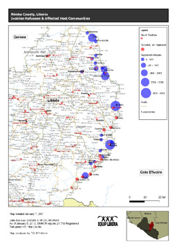
Liberia
Map on Ivorian refugees in Nimba County
Ivoirian Refugees & Affected Host Communities (as of 07 Jan 2011) (Map or infographic, English)