Maps
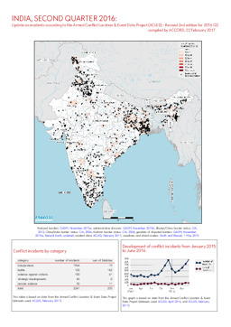
Update on conflict-related incidents according to the Armed Conflict Location & Event Data Project (covering 2nd quarter 2016) (revised edition)
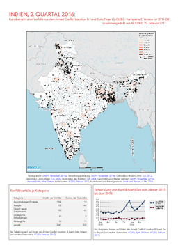
Indien, 2. Quartal 2016: Kurzübersicht über Vorfälle aus dem Armed Conflict Location & Event Data Project (ACLED) - Korrigierte 2. Version für 2016 Q2 (Map or infographic, German)
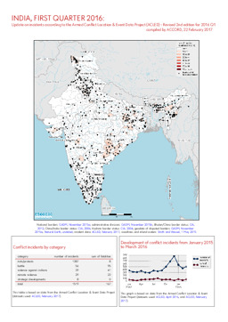
Update on conflict-related incidents according to the Armed Conflict Location & Event Data Project (covering first quarter 2016) (revised edition)
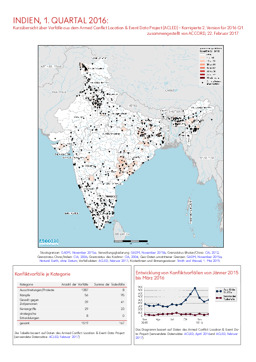
Indien, 1. Quartal 2016: Kurzübersicht über Vorfälle aus dem Armed Conflict Location & Event Data Project (ACLED) - Korrigierte 2. Version für 2016 Q1 (Map or infographic, English)
Update on conflict-related incidents according to the Armed Conflict Location & Event Data Project (covering first quarter 2016) (revised edition)
Indien, 1. Quartal 2016: Kurzübersicht über Vorfälle aus dem Armed Conflict Location & Event Data Project (ACLED) - Korrigierte 2. Version für 2016 Q1 (Map or infographic, German)
Update on conflict-related incidents according to the Armed Conflict Location & Event Data Project (covering 2nd quarter 2016) (revised edition)
Indien, 2. Quartal 2016: Kurzübersicht über Vorfälle aus dem Armed Conflict Location & Event Data Project (ACLED) - Korrigierte 2. Version für 2016 Q2 (Map or infographic, English)
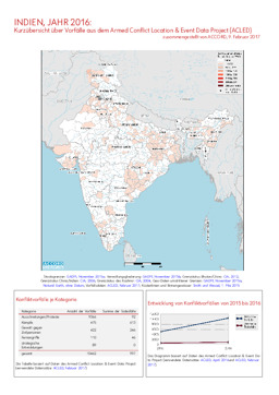
Update on incidents according to the Armed Conflict Location & Event Data Project (covering 2016)
Indien, Jahr 2016: Kurzübersicht über Vorfälle aus dem Armed Conflict Location & Event Data Project (ACLED) (Map or infographic, German)
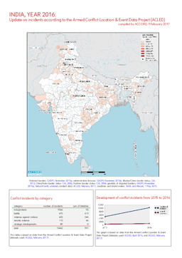
Update on incidents according to the Armed Conflict Location & Event Data Project (covering 2016)
Indien, Jahr 2016: Kurzübersicht über Vorfälle aus dem Armed Conflict Location & Event Data Project (ACLED) (Map or infographic, English)
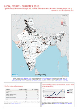
Update on incidents according to the Armed Conflict Location & Event Data Project (covering 4th quarter 2016)
Indien, 4. Quartal 2016: Kurzübersicht über Vorfälle aus dem Armed Conflict Location & Event Data Project (ACLED) (Map or infographic, English)
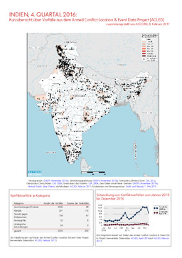
Update on incidents according to the Armed Conflict Location & Event Data Project (covering 4th quarter 2016)
Indien, 4. Quartal 2016: Kurzübersicht über Vorfälle aus dem Armed Conflict Location & Event Data Project (ACLED) (Map or infographic, German)
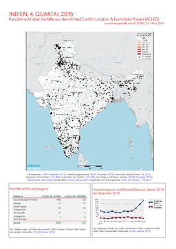
Update on conflict-related incidents according to the Armed Conflict Location & Event Data Project (covering fourth quarter 2015)
Indien, 4. Quartal 2015: Kurzübersicht über Vorfälle aus dem Armed Conflict Location & Event Data Project (ACLED) (Map or infographic, German)
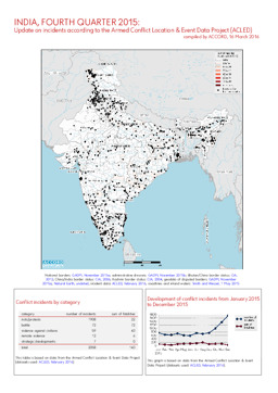
Update on conflict-related incidents according to the Armed Conflict Location & Event Data Project (covering fourth quarter 2015)
Indien, 4. Quartal 2015: Kurzübersicht über Vorfälle aus dem Armed Conflict Location & Event Data Project (ACLED) (Map or infographic, English)
Documents found: 86
