This page gives you an overview on maps about Eritrea collected on ecoi.net. More maps are available in our full-text search.
Infrastructure and administrative divisions
In 2009, the University of Texas Libraries published a map with administrative divisions as well as roads, the railway system and airfields in Eritrea and Ethiopia:
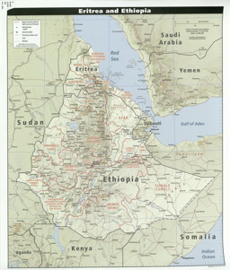
Thematic map on infrastructure (roads; railroad; airfields) with administrative divisions (regional level)
Eritrea and Ethiopia 2009 (Map or infographic, English)

Cities
A map published on 28 February 2006 by UN OCHA shows cities and villages:
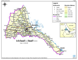
Political map with cities and villages
Eritrea: Briefing Map (Map or infographic, English)
Ethnic groups
A country report by the European Asylum Support Office (EASO) contains on page 13 a map by the Swiss State Secretariat on Migration (SEM), which shows the distribution of ethnic groups and languages in Eritrea and bordering regions:
-
Country report (background; state structure and politics; National Service; detention conditions; religion; ID documents and exiting the country) (see update ID 333795; also see ARC & DCR comment on this report: ID 310050)
Eritrea Country Focus (Special or Analytical Report, English)
More maps
More maps and infographics with the option to use filters can be found in the ecoi.net search: Eritrea maps on ecoi.net. Please note that the recognition of text in graphical documents such as maps often does not work well. This means that place names often can't be found in the full-text search, even when the name is visible on a map.

- Austrian Red Cross
- Austrian Centre for Country of Origin and Asylum Research and Documentation (ACCORD)
- Wiedner Hauptstraße 32, 1041 Wien
- T +43 1 589 00 583
- F +43 1 589 00 589
- info@ecoi.net
ecoi.net is run by the Austrian Red Cross (department ACCORD) in cooperation with Informationsverbund Asyl & Migration. ecoi.net is funded by the Asylum, Migration and Integration Fund, the Austrian Ministry of the Interior and Caritas Austria. ecoi.net is supported by ECRE & UNHCR.