Maps
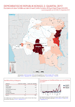
Update on conflict-related incidents according to the Armed Conflict Location & Event Data Project (covering second quarter 2017)
Demokratische Republik Kongo, 2. Quartal 2017: Kurzübersicht über Vorfälle aus dem Armed Conflict Location & Event Data Project (ACLED) (Map or infographic, German)
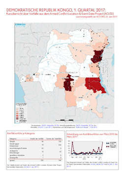
Update on conflict-related incidents according to the Armed Conflict Location & Event Data Project (covering first quarter 2017)
Demokratische Republik Kongo, 1. Quartal 2017: Kurzübersicht über Vorfälle aus dem Armed Conflict Location & Event Data Project (ACLED) (Map or infographic, German)
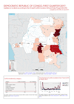
Update on conflict-related incidents according to the Armed Conflict Location & Event Data Project (covering first quarter 2017)
Demokratische Republik Kongo, 1. Quartal 2017: Kurzübersicht über Vorfälle aus dem Armed Conflict Location & Event Data Project (ACLED) (Map or infographic, English)
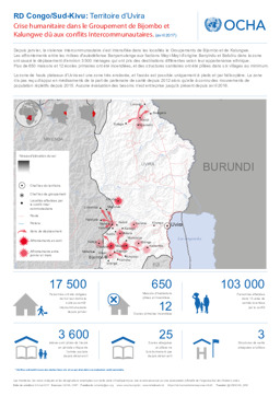
South Kivu province: Situation map on intercommunal violence and the humanitarian situation in the Uvira area (as of April 2017)
RDC Congo/Sud-Kivu: Territoire d'Uvira; Crise humanitaire dans le Groupement de Bijombo et Kalungwe dû aux conflits Intercommunautaires. (avril 2017) (Map or infographic, French)
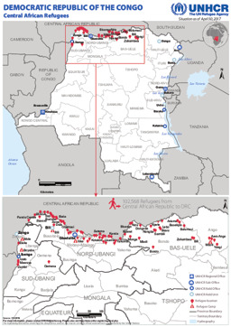
Situation map on the distribution of refugees from the Central African Republic in the Democratic Republic of Congo (as of 30 April 2017)
Democratic Republic of the Congo; Central African Refugees; Situation as of April 30, 2017 (Map or infographic, English)
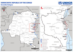
Situation map on the distribution of Burundian refugees in the Democratic Republic of the Congo (as of 30 April 2017)
Democratic Republic of the Congo; Burundian Refugees; Situation as of April 30, 2017 (Map or infographic, English)
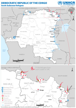
Situation map on the distribution of South Sudanese refugees in the Democratic Republic of the Congo (as of 30 April 2017)
Democratic Republic of the Congo; South Sudanese Refugees; Situation as of April 30, 2017 (Map or infographic, English)

Situation map on the distribution of Burundian refugees in the Democratic Republic of the Congo (as of 31 March 2017)
Democratic Republic of the Congo; Burundian Refugees; Situation as of March 31, 2017 (Map or infographic, English)
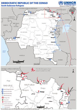
Situation map on the distribution of South Sudanese refugees in the Democratic Republic of the Congo (as of 31 March 2017)
Democratic Republic of the Congo; South Sudanese Refugees; Situation as of March 31, 2017 (Map or infographic, English)
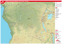
Thematic map on infrastructure (roads; railway; airports) with main cities, water bodies and administrative divisions (province level)
Democratic Republic of the Congo - Basemap (as of 17 Feb 2017) (Map or infographic, English)
Documents found: 552
