ecoi.net
  • Countries
    • Show all countries
  • About us
    • About ecoi.net
    • Our Sources
    • Our publications
    • Search Help
    • F.A.Q.
    • Contact
    • Data Protection Notice
    • Imprint & Disclaimer
  • COI Resources
    • Quality Standards
    • Training
    • COI Thesaurus
    • Other resources
  • Blog
  • Search
  • My ecoi.net
  • Language:
  • en
  • de

Document #1210659

UN Cartographic Section (Author)

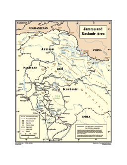
Jammu and Kashmir Area


https://digitallibrary.un.org/record/718165/files/3953_Rev-_4.pdf?ln=en

ecoi.net description:
Jammu and Kashmir: Political map with administrative divisions (provincial level), main cities and infrastructure (roads; airports) (as of December 2011)
Countries:
India, Pakistan
Source:
UN Cartographic Section (Author)
Published:
December 2011
Original link:
https://digitallibrary.un.org/record/718165/files/3953_Rev-_4.pdf?ln=en
Document type:
Map or infographic
Language:
English
Document ID:
1210659 (former ID 134851)
ecoi.net
  • Austrian Red Cross
  • Austrian Centre for Country of Origin and Asylum Research and Documentation (ACCORD)
  • Wiedner Hauptstraße 32, 1041 Wien
  • T +43 1 589 00 583
  • F +43 1 589 00 589
  • info@ecoi.net
  • Contact
  • Imprint & Disclaimer
  • F.A.Q.
  • Data Protection Notice

ecoi.net is run by the Austrian Red Cross (department ACCORD) in cooperation with Informationsverbund Asyl & Migration. ecoi.net is funded by the Asylum, Migration and Integration Fund, the Austrian Ministry of the Interior and Caritas Austria. ecoi.net is supported by ECRE & UNHCR.

  • Logo: Austrian Red Cross
  • Logo: Austrian Centre for Country of Origin and Asylum Research and Documentation
  • Logo: Asylum, Migration and Integration Fund (AMIF) - European Union
  • Logo: Federal Ministry of the Interior (Austria)
  • Logo: Informationsverbund Asyl & Migration
  • Logo: UNHCR - The UN Refugee Agency