2 September 2015 | UNHCR – UN High Commissioner for Refugees (Author)
Sudan
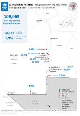
Map on new arrivals from South Sudan at refugee sites in White Nile State
SUDAN: White Nile State - Refugee sites hosting new arrivals from South Sudan; 15 December 2013 – 2 September 2015 (Map or infographic, English)
1 September 2015 | UNHCR – UN High Commissioner for Refugees (Author)
Djibouti, Ethiopia, Oman, Saudi Arabia, Somalia, Sudan
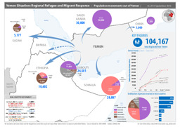
Situation map on movements of refugees and migrants from Yemen into neighbouring countries (as of 1 September 2015)
Yemen Situation: Regional Refugee and Migrant Response – Population movements out of Yemen; As of 01 September 2015 (Map or infographic, English)
5 August 2015 | UNHCR – UN High Commissioner for Refugees (Author)
Ethiopia, Kenya, South Sudan, Sudan, Uganda
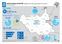
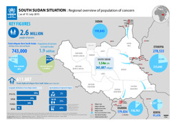
Infographic on a regional overview of the population of concern (as of 5 August 2015)
SOUTH SUDAN SITUATION : Regional overview of population of concern; as of 05 August 2015 (Map or infographic, English)
5 August 2015 | UNHCR – UN High Commissioner for Refugees (Author)
Sudan
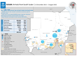
Map on the distribution of new arrivals from South Sudan
SUDAN: Arrivals from South Sudan; 15 December 2013 – 5 August 2015 (Map or infographic, English)
August 2015 | BFA Staatendokumentation (Austrian Federal Office for Immigration and Asylum, COI unit) (Author)
Afghanistan, Albania, Algeria, Angola, Argentina, Armenia, Australia, Austria, Azerbaijan, Bahrain, Bangladesh, Belarus, Belgium, Benin, Bhutan, Bolivia, Bosnia and Herzegovina, Botswana, Brazil, Bulgaria, Burkina Faso, Burundi, Cambodia, Cameroon, Canada, Central African Republic, Chad, Chile, China, Colombia, Congo, Congo, Democratic Republic, Costa Rica, Croatia, Cuba, Cyprus, Czech Republic, Côte d'Ivoire, Denmark, Djibouti, Dominican Republic, Ecuador, Egypt, El Salvador, Equatorial Guinea, Eritrea, Estonia, Eswatini, Ethiopia, Finland, France, Gabon, Gambia, Georgia, Germany, Ghana, Greece, Guatemala, Guinea, Guinea-Bissau, Haiti, Honduras, Hungary, Iceland, India, Indonesia, Iran, Iraq, Ireland, Israel, Italy, Jamaica, Japan, Jordan, Kazakhstan, Kenya, Korea, Democratic People's Republic, Korea, Republic, Kosovo, Kuwait, Kyrgyzstan, Lao People's Democratic Republic, Latvia, Lebanon, Lesotho, Liberia, Libya, Liechtenstein, Lithuania, Luxembourg, Madagascar, Malawi, Malaysia, Maldives, Mali, Malta, Mauritania, Mexico, Moldova, Republic, Mongolia, Montenegro, Morocco, Mozambique, Myanmar, Namibia, Nepal, Netherlands, New Zealand, Nicaragua, Niger, Nigeria, North Macedonia, Norway, Oman, Pakistan, Panama, Paraguay, Peru, Philippines, Poland, Portugal, Qatar, Romania, Russian Federation, Rwanda, Saudi Arabia, Senegal, Serbia, Sierra Leone, Singapore, Slovakia, Slovenia, Somalia, South Africa, South Sudan, Spain, Sri Lanka, State of Palestine, Sudan, Suriname, Sweden, Switzerland, Syrian Arab Republic, Taiwan, Tajikistan, Tanzania, United Republic, Thailand, Timor-Leste, Togo, Tunisia, Turkmenistan, Türkiye, Uganda, Ukraine, United Arab Emirates, United Kingdom, United States of America, Uruguay, Uzbekistan, Venezuela, Vietnam, Western Sahara, Yemen, Zambia, Zimbabwe
Infographics: Thematic atlas on demography and migration, globally and in Europe (population density; population age; migration; displacement)
Atlas Demographie & Migration 2015 (Map or infographic, German)
August 2015 | BFA Staatendokumentation (Austrian Federal Office for Immigration and Asylum, COI unit) (Author)
Afghanistan, Albania, Algeria, Angola, Argentina, Armenia, Australia, Austria, Azerbaijan, Bahrain, Bangladesh, Belarus, Belgium, Benin, Bhutan, Bolivia, Bosnia and Herzegovina, Botswana, Brazil, Bulgaria, Burkina Faso, Burundi, Cambodia, Cameroon, Canada, Central African Republic, Chad, Chile, China, Colombia, Congo, Congo, Democratic Republic, Costa Rica, Croatia, Cuba, Cyprus, Czech Republic, Côte d'Ivoire, Denmark, Djibouti, Dominican Republic, Ecuador, Egypt, El Salvador, Equatorial Guinea, Eritrea, Estonia, Eswatini, Ethiopia, Finland, France, Gabon, Gambia, Georgia, Germany, Ghana, Greece, Guatemala, Guinea, Guinea-Bissau, Haiti, Honduras, Hungary, Iceland, India, Indonesia, Iran, Iraq, Ireland, Israel, Italy, Jamaica, Japan, Jordan, Kazakhstan, Kenya, Korea, Democratic People's Republic, Korea, Republic, Kosovo, Kuwait, Kyrgyzstan, Lao People's Democratic Republic, Latvia, Lebanon, Lesotho, Liberia, Libya, Liechtenstein, Lithuania, Luxembourg, Madagascar, Malawi, Malaysia, Maldives, Mali, Malta, Mauritania, Mexico, Moldova, Republic, Mongolia, Montenegro, Morocco, Mozambique, Myanmar, Namibia, Nepal, Netherlands, New Zealand, Nicaragua, Niger, Nigeria, North Macedonia, Norway, Oman, Pakistan, Panama, Paraguay, Peru, Philippines, Poland, Portugal, Qatar, Romania, Russian Federation, Rwanda, Saudi Arabia, Senegal, Serbia, Sierra Leone, Singapore, Slovakia, Slovenia, Somalia, South Africa, South Sudan, Spain, Sri Lanka, State of Palestine, Sudan, Suriname, Sweden, Switzerland, Syrian Arab Republic, Taiwan, Tajikistan, Tanzania, United Republic, Thailand, Timor-Leste, Togo, Tunisia, Turkmenistan, Türkiye, Uganda, Ukraine, United Arab Emirates, United Kingdom, United States of America, Uruguay, Uzbekistan, Venezuela, Vietnam, Western Sahara, Yemen, Zambia, Zimbabwe
Infographics: Thematic atlas on demography and migration, globally and in Europe (population density; population age; migration; displacement)
Atlas Demography & Migration 2015 (Map or infographic, English)
31 July 2015 | UNHCR – UN High Commissioner for Refugees (Author)
Ethiopia, Kenya, South Sudan, Sudan, Uganda
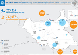
Situation map on the distribution of refugees in South Sudan and South Sudanese refugees in neighbouring countries (as of 31 August 2015)
SOUTH SUDAN: Refugees residing in and originating from South Sudan; 31 August 2015 (Map or infographic, English)
22 July 2015 | UNHCR – UN High Commissioner for Refugees (Author)
Sudan
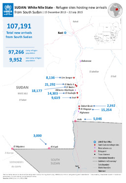
Map on new arrivals from South Sudan at refugee sites in White Nile State
SUDAN: White Nile State - Refugee sites hosting new arrivals from South Sudan (Map or infographic, English)
22 July 2015 | UNHCR – UN High Commissioner for Refugees (Author)
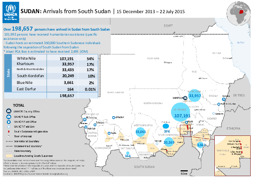
Sudan
Map on the distribution of individuals from South Sudan in Sudan
SUDAN: Arrivals from South Sudan; 15 December 2013 – 22 July 2015 (Map or infographic, English)
20 July 2015 | UNHCR – UN High Commissioner for Refugees (Author)
Ethiopia, Kenya, South Sudan, Sudan, Uganda
Infographic on the distribution of IDPs in South Sudan and South Sudanese refugees in the region (as of 15 July 2015)
SOUTH SUDAN SITUATION : Regional overview of population of concern | as of 15 July 2015 (Map or infographic, English)
