This page gives you an overview on maps about Nigeria collected on ecoi.net. More maps are available in our full-text search.
Ethnolinguistic groups
In 1979, the University of Texas Libraries published a CIA map on the distribution of ethnolinguistic groups:
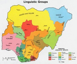
Population map on the distribution of ethnolinguistic groups
Nigeria - Ethnolinguistic Groups (Map or infographic, English)

In 1967, the US Library of Congress published a map on the distribution of languages and dialects:
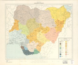
Population map on the distribution of languages and dialects
Nigeria, languages & dialects (Map or infographic, English)

Administrative divisions
In 2018, the CIA published a map with state boundaries and state capitals:
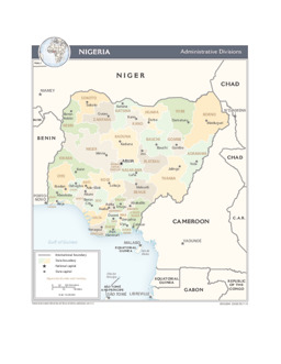
Political map on administrative divisions (state level) with main cities (state capitals)
Nigeria (Administrative Divisions) 2015 (Map or infographic, English)
Religion
An article by Cletus Famous Nwankwo from 27 March 2019 contains a map on the distribution of the Muslim population in the country and a table on the percentage distribution of religions by states:
-
Background article on the situation of religion and its influence on voter choice homogeneity in presidential elections (with information on the religious geography by state)
Religion and Voter Choice Homogeneity in the Nigerian Presidential Elections of the Fourth Republic (Appeal or News Release, English)
Infastructure
The UN Cartographic Section in August 2014 published a map on infrastructure (roads, railway lines, airports) and main cities:
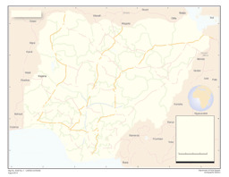
Thematic map on infrastructure (roads; railway; airports) with main cities
Nigeria (Map or infographic, English)
Physiography
In 2018, the CIA released a map on physiography:
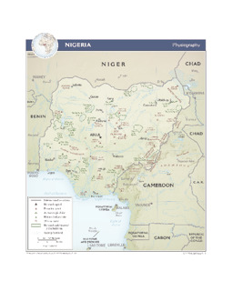
Physical map on physiography
Nigeria (Physiography) 2015 (Map or infographic, English)
More maps
More maps and infographics with the option to use filters can be found in the ecoi.net search: Nigeria maps on ecoi.net. Please note that the recognition of text in graphical documents such as maps often does not work well. This means that place names often can't be found in the full-text search, even when the name is visible on a map.

- Austrian Red Cross
- Austrian Centre for Country of Origin and Asylum Research and Documentation (ACCORD)
- Wiedner Hauptstraße 32, 1041 Wien
- T +43 1 589 00 583
- F +43 1 589 00 589
- info@ecoi.net
ecoi.net is run by the Austrian Red Cross (department ACCORD) in cooperation with Informationsverbund Asyl & Migration. ecoi.net is funded by the Asylum, Migration and Integration Fund, the Austrian Ministry of the Interior and Caritas Austria. ecoi.net is supported by ECRE & UNHCR.