Maps
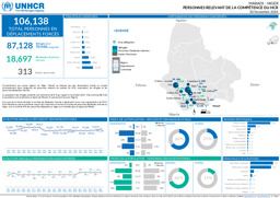
Maradi: Infographic on persons of concern to UNHCR (as of 31 December 2024)
Maradi - Niger; Personnes Relevant de la Compétence du HCR; 31 Decembre 2024 (Map or infographic, French)
Infographic with administrative divisions (province level) on the distribution of persons of concern to UNHCR (as of 31 December 2024)
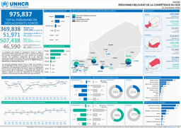
Niger; Personnes Relevant de la Compéptence du HCR; 31 Decembre 2024 (Map or infographic, French)
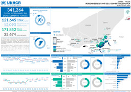
Diffa: Infographic on persons of concern to UNHCR (as of 30 November 2024)
Diffa - Niger; Personnes Relevant de la Compétence du HCR; 30 Novembre 2024 (Map or infographic, French)
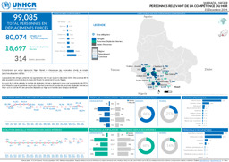
Maradi: Infographic on persons of concern to UNHCR (as of 30 November 2024)
Maradi - Niger; Personnes relevant de la compétence du HCR; 30 Novembre 2024 (Map or infographic, French)

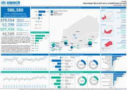
Tahoua: Infographic on persons of concern to UNHCR (as of 30 November 2024)
Tahoua - Niger; Personnes Relevant de la Compétence du HCR; 30 Novembre 2024 (Map or infographic, French)
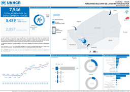
Agadez: Infographic on persons of concern to UNHCR (as of 30 November 2024)
Agadez - Niger; Personnes Relevant de la Compétence du HCR, 30 Novembre 2024 (Map or infographic, French)
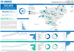
Tillaberi: Infographic on persons of concern to UNHCR (as of 30 November 2024)
Tillabéri - Niger; Personnes Relevant de la Compétence du HCR; 30 Novembre 2024 (Map or infographic, English)
Infographic with administrative divisions (province level) on the distribution of persons of concern to UNHCR (as of 30 November 2024)
Niger; Personnes Relevant de la Compétence du HCR; 30 Novembre 2024 (Map or infographic, French)
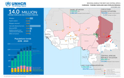
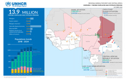
Infographics on the distribution of forcibly displaced and stateless persons (as of November 2024)
Regional Bureau for West and Central Africa; Overview - Forcibly Displaced and Stateless Persons; November 2024 (Map or infographic, English)
Infographics on the distribution of forcibly displaced and stateless persons (as of October 2024)
Regional Bureau for West and Central Africa; Overview - Forcibly Displaced and Stateless Persons; October 2024 (Map or infographic, English)
Documents found: 448
